You are here: Home > Network List > IU - Global Seismograph Network (GSN - IRIS/USGS) Stations List
> Station GUMO Guam, Mariana Islands > Earthquake Result Viewer
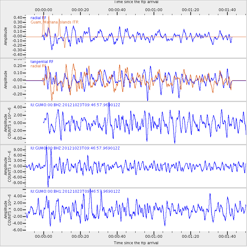
GUMO Guam, Mariana Islands - Earthquake Result Viewer
*The percent match for this event was below the threshold and hence no stack was calculated.
| Earthquake location: |
Southeast Of Loyalty Islands |
| Earthquake latitude/longitude: |
-22.3/171.7 |
| Earthquake time(UTC): |
2012/10/23 (297) 09:39:30 GMT |
| Earthquake Depth: |
123 km |
| Earthquake Magnitude: |
5.9 MB, 5.8 MW, 5.9 MW |
| Earthquake Catalog/Contributor: |
WHDF/NEIC |
|
| Network: |
IU Global Seismograph Network (GSN - IRIS/USGS) |
| Station: |
GUMO Guam, Mariana Islands |
| Lat/Lon: |
13.59 N/144.87 E |
| Elevation: |
170 m |
|
| Distance: |
44.3 deg |
| Az: |
321.1 deg |
| Baz: |
143.27 deg |
| Ray Param: |
$rayparam |
*The percent match for this event was below the threshold and hence was not used in the summary stack. |
|
| Radial Match: |
53.835674 % |
| Radial Bump: |
400 |
| Transverse Match: |
55.84616 % |
| Transverse Bump: |
400 |
| SOD ConfigId: |
558545 |
| Insert Time: |
2013-09-17 21:32:32.414 +0000 |
| GWidth: |
2.5 |
| Max Bumps: |
400 |
| Tol: |
0.001 |
|
Signal To Noise
| Channel | StoN | STA | LTA |
| IU:GUMO:00:BHZ:20121023T09:46:57.969012Z | 4.615706 | 5.5008595E-6 | 1.1917699E-6 |
| IU:GUMO:00:BH1:20121023T09:46:57.969012Z | 1.8835125 | 2.211863E-6 | 1.1743288E-6 |
| IU:GUMO:00:BH2:20121023T09:46:57.969012Z | 0.80760294 | 1.236828E-6 | 1.5314803E-6 |
| Arrivals |
| Ps | |
| PpPs | |
| PsPs/PpSs | |


