You are here: Home > Network List > US - United States National Seismic Network Stations List
> Station TPNV Topopah Spring, Nevada, USA > Earthquake Result Viewer
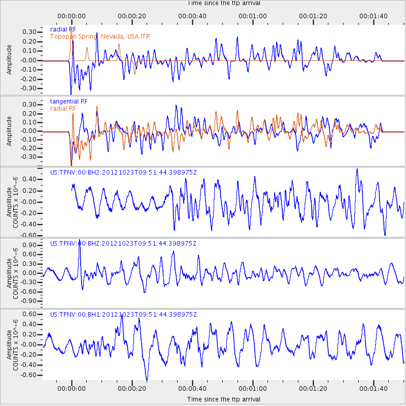
TPNV Topopah Spring, Nevada, USA - Earthquake Result Viewer
*The percent match for this event was below the threshold and hence no stack was calculated.
| Earthquake location: |
Southeast Of Loyalty Islands |
| Earthquake latitude/longitude: |
-22.3/171.7 |
| Earthquake time(UTC): |
2012/10/23 (297) 09:39:30 GMT |
| Earthquake Depth: |
123 km |
| Earthquake Magnitude: |
5.9 MB, 5.8 MW, 5.9 MW |
| Earthquake Catalog/Contributor: |
WHDF/NEIC |
|
| Network: |
US United States National Seismic Network |
| Station: |
TPNV Topopah Spring, Nevada, USA |
| Lat/Lon: |
36.95 N/116.25 W |
| Elevation: |
1600 m |
|
| Distance: |
89.9 deg |
| Az: |
49.655 deg |
| Baz: |
241.763 deg |
| Ray Param: |
$rayparam |
*The percent match for this event was below the threshold and hence was not used in the summary stack. |
|
| Radial Match: |
57.815903 % |
| Radial Bump: |
400 |
| Transverse Match: |
59.921978 % |
| Transverse Bump: |
400 |
| SOD ConfigId: |
558545 |
| Insert Time: |
2013-09-17 21:33:51.975 +0000 |
| GWidth: |
2.5 |
| Max Bumps: |
400 |
| Tol: |
0.001 |
|
Signal To Noise
| Channel | StoN | STA | LTA |
| US:TPNV:00:BHZ:20121023T09:51:44.398975Z | 3.3431723 | 3.4885738E-7 | 1.0434921E-7 |
| US:TPNV:00:BH1:20121023T09:51:44.398975Z | 0.96362 | 1.3289387E-7 | 1.3791107E-7 |
| US:TPNV:00:BH2:20121023T09:51:44.398975Z | 1.3107116 | 1.8805935E-7 | 1.434788E-7 |
| Arrivals |
| Ps | |
| PpPs | |
| PsPs/PpSs | |


