You are here: Home > Network List > US - United States National Seismic Network Stations List
> Station GLMI Grayling, Michigan, USA > Earthquake Result Viewer
GLMI Grayling, Michigan, USA - Earthquake Result Viewer

| Earthquake location: |
Costa Rica |
| Earthquake latitude/longitude: |
10.1/-85.3 |
| Earthquake time(UTC): |
2012/10/24 (298) 00:45:32 GMT |
| Earthquake Depth: |
17 km |
| Earthquake Magnitude: |
6.0 MB, 6.2 MS, 6.5 MW, 6.4 MW |
| Earthquake Catalog/Contributor: |
WHDF/NEIC |
|
| Network: |
US United States National Seismic Network |
| Station: |
GLMI Grayling, Michigan, USA |
| Lat/Lon: |
44.82 N/84.62 W |
| Elevation: |
387 m |
|
| Distance: |
34.6 deg |
| Az: |
0.853 deg |
| Baz: |
181.18 deg |
| Ray Param: |
0.077632524 |
| Estimated Moho Depth: |
21.0 km |
| Estimated Crust Vp/Vs: |
1.67 |
| Assumed Crust Vp: |
6.483 km/s |
| Estimated Crust Vs: |
3.888 km/s |
| Estimated Crust Poisson's Ratio: |
0.22 |
|
| Radial Match: |
85.767746 % |
| Radial Bump: |
400 |
| Transverse Match: |
64.27249 % |
| Transverse Bump: |
400 |
| SOD ConfigId: |
558545 |
| Insert Time: |
2013-09-17 21:36:57.973 +0000 |
| GWidth: |
2.5 |
| Max Bumps: |
400 |
| Tol: |
0.001 |
|
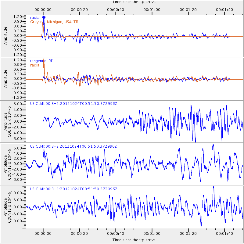
Signal To Noise
| Channel | StoN | STA | LTA |
| US:GLMI:00:BHZ:20121024T00:51:50.372996Z | 2.9301698 | 2.7007322E-6 | 9.216982E-7 |
| US:GLMI:00:BH1:20121024T00:51:50.372996Z | 2.0105124 | 2.0515745E-6 | 1.0204237E-6 |
| US:GLMI:00:BH2:20121024T00:51:50.372996Z | 1.4507893 | 1.3370152E-6 | 9.215778E-7 |
| Arrivals |
| Ps | 2.4 SECOND |
| PpPs | 7.9 SECOND |
| PsPs/PpSs | 10 SECOND |


