You are here: Home > Network List > US - United States National Seismic Network Stations List
> Station LONY Lake Ozonia, New York, USA > Earthquake Result Viewer
LONY Lake Ozonia, New York, USA - Earthquake Result Viewer
| Earthquake location: |
Costa Rica |
| Earthquake latitude/longitude: |
10.1/-85.3 |
| Earthquake time(UTC): |
2012/10/24 (298) 00:45:32 GMT |
| Earthquake Depth: |
17 km |
| Earthquake Magnitude: |
6.0 MB, 6.2 MS, 6.5 MW, 6.4 MW |
| Earthquake Catalog/Contributor: |
WHDF/NEIC |
|
| Network: |
US United States National Seismic Network |
| Station: |
LONY Lake Ozonia, New York, USA |
| Lat/Lon: |
44.62 N/74.58 W |
| Elevation: |
440 m |
|
| Distance: |
35.6 deg |
| Az: |
13.174 deg |
| Baz: |
198.317 deg |
| Ray Param: |
0.077102005 |
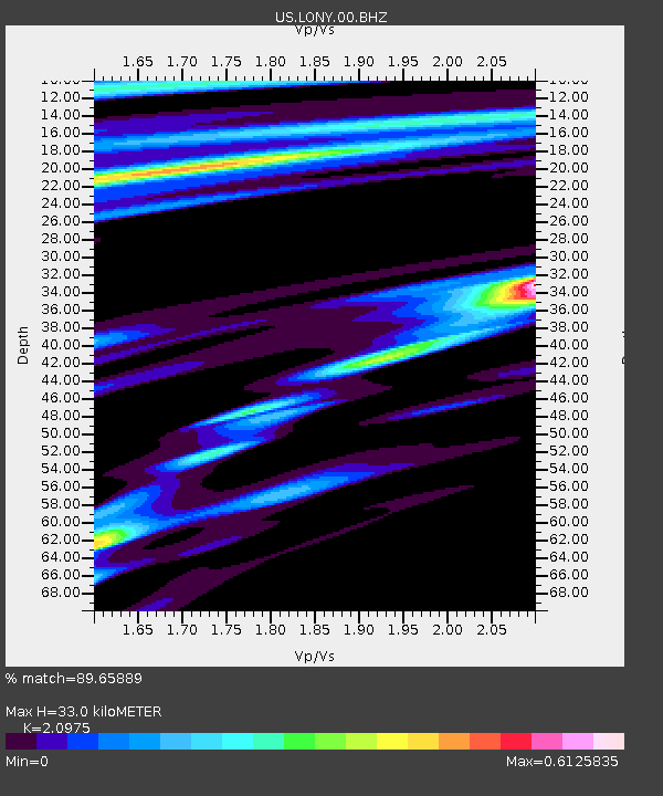
| Estimated Moho Depth: |
33.0 km |
| Estimated Crust Vp/Vs: |
2.10 |
| Assumed Crust Vp: |
6.419 km/s |
| Estimated Crust Vs: |
3.06 km/s |
| Estimated Crust Poisson's Ratio: |
0.35 |
|
| Radial Match: |
89.65889 % |
| Radial Bump: |
371 |
| Transverse Match: |
66.753296 % |
| Transverse Bump: |
397 |
| SOD ConfigId: |
558545 |
| Insert Time: |
2013-09-17 21:37:33.499 +0000 |
| GWidth: |
2.5 |
| Max Bumps: |
400 |
| Tol: |
0.001 |
|
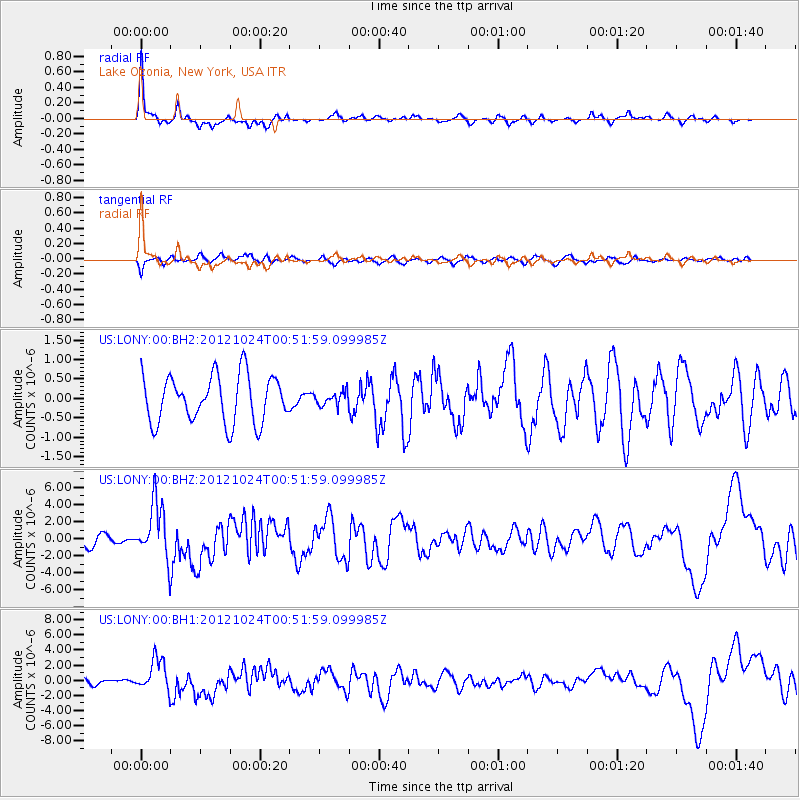
Signal To Noise
| Channel | StoN | STA | LTA |
| US:LONY:00:BHZ:20121024T00:51:59.099985Z | 4.913103 | 3.3073836E-6 | 6.731761E-7 |
| US:LONY:00:BH1:20121024T00:51:59.099985Z | 4.2640624 | 2.1319522E-6 | 4.9998147E-7 |
| US:LONY:00:BH2:20121024T00:51:59.099985Z | 0.28496423 | 1.7156646E-7 | 6.020631E-7 |
| Arrivals |
| Ps | 6.0 SECOND |
| PpPs | 15 SECOND |
| PsPs/PpSs | 21 SECOND |


