You are here: Home > Network List > US - United States National Seismic Network Stations List
> Station MSO Missoula, Montana, USA > Earthquake Result Viewer
MSO Missoula, Montana, USA - Earthquake Result Viewer
*The percent match for this event was below the threshold and hence no stack was calculated.
| Earthquake location: |
Costa Rica |
| Earthquake latitude/longitude: |
10.1/-85.3 |
| Earthquake time(UTC): |
2012/10/24 (298) 00:45:32 GMT |
| Earthquake Depth: |
17 km |
| Earthquake Magnitude: |
6.0 MB, 6.2 MS, 6.5 MW, 6.4 MW |
| Earthquake Catalog/Contributor: |
WHDF/NEIC |
|
| Network: |
US United States National Seismic Network |
| Station: |
MSO Missoula, Montana, USA |
| Lat/Lon: |
46.83 N/113.94 W |
| Elevation: |
1264 m |
|
| Distance: |
44.0 deg |
| Az: |
331.693 deg |
| Baz: |
137.15 deg |
| Ray Param: |
$rayparam |
*The percent match for this event was below the threshold and hence was not used in the summary stack. |
|
| Radial Match: |
71.7324 % |
| Radial Bump: |
400 |
| Transverse Match: |
62.713802 % |
| Transverse Bump: |
400 |
| SOD ConfigId: |
558545 |
| Insert Time: |
2013-09-17 21:37:33.982 +0000 |
| GWidth: |
2.5 |
| Max Bumps: |
400 |
| Tol: |
0.001 |
|
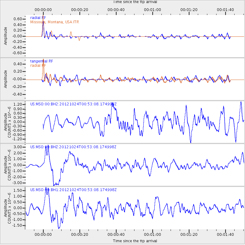
Signal To Noise
| Channel | StoN | STA | LTA |
| US:MSO:00:BHZ:20121024T00:53:08.174998Z | 5.1728926 | 1.7067491E-6 | 3.2994095E-7 |
| US:MSO:00:BH1:20121024T00:53:08.174998Z | 3.1247082 | 1.0384608E-6 | 3.3233852E-7 |
| US:MSO:00:BH2:20121024T00:53:08.174998Z | 1.9491593 | 5.323871E-7 | 2.731368E-7 |
| Arrivals |
| Ps | |
| PpPs | |
| PsPs/PpSs | |


