You are here: Home > Network List > UW - Pacific Northwest Regional Seismic Network Stations List
> Station YACT Amboy, WA, USA > Earthquake Result Viewer
YACT Amboy, WA, USA - Earthquake Result Viewer
| Earthquake location: |
Taiwan Region |
| Earthquake latitude/longitude: |
24.1/122.2 |
| Earthquake time(UTC): |
2009/07/13 (194) 18:05:01 GMT |
| Earthquake Depth: |
17 km |
| Earthquake Magnitude: |
6.1 MB, 6.3 MS, 6.3 MW, 6.2 MW |
| Earthquake Catalog/Contributor: |
WHDF/NEIC |
|
| Network: |
UW Pacific Northwest Regional Seismic Network |
| Station: |
YACT Amboy, WA, USA |
| Lat/Lon: |
45.93 N/122.42 W |
| Elevation: |
211 m |
|
| Distance: |
89.0 deg |
| Az: |
39.098 deg |
| Baz: |
304.305 deg |
| Ray Param: |
0.042132437 |
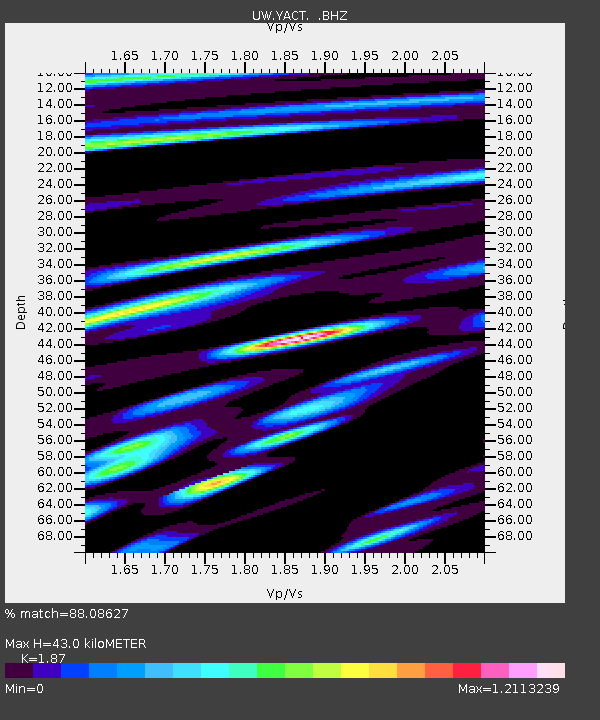
| Estimated Moho Depth: |
43.0 km |
| Estimated Crust Vp/Vs: |
1.87 |
| Assumed Crust Vp: |
6.566 km/s |
| Estimated Crust Vs: |
3.511 km/s |
| Estimated Crust Poisson's Ratio: |
0.30 |
|
| Radial Match: |
88.08627 % |
| Radial Bump: |
400 |
| Transverse Match: |
82.575066 % |
| Transverse Bump: |
400 |
| SOD ConfigId: |
2648 |
| Insert Time: |
2010-02-27 05:21:40.388 +0000 |
| GWidth: |
2.5 |
| Max Bumps: |
400 |
| Tol: |
0.001 |
|

Signal To Noise
| Channel | StoN | STA | LTA |
| UW:YACT: :BHZ:20090713T18:17:23.825029Z | 17.071154 | 9.892785E-7 | 5.79503E-8 |
| UW:YACT: :BHN:20090713T18:17:23.825029Z | 1.9319655 | 1.0034275E-7 | 5.193817E-8 |
| UW:YACT: :BHE:20090713T18:17:23.825029Z | 4.528174 | 2.2669063E-7 | 5.006226E-8 |
| Arrivals |
| Ps | 5.8 SECOND |
| PpPs | 18 SECOND |
| PsPs/PpSs | 24 SECOND |


