You are here: Home > Network List > US - United States National Seismic Network Stations List
> Station HAWA Hanford, Washington, USA > Earthquake Result Viewer
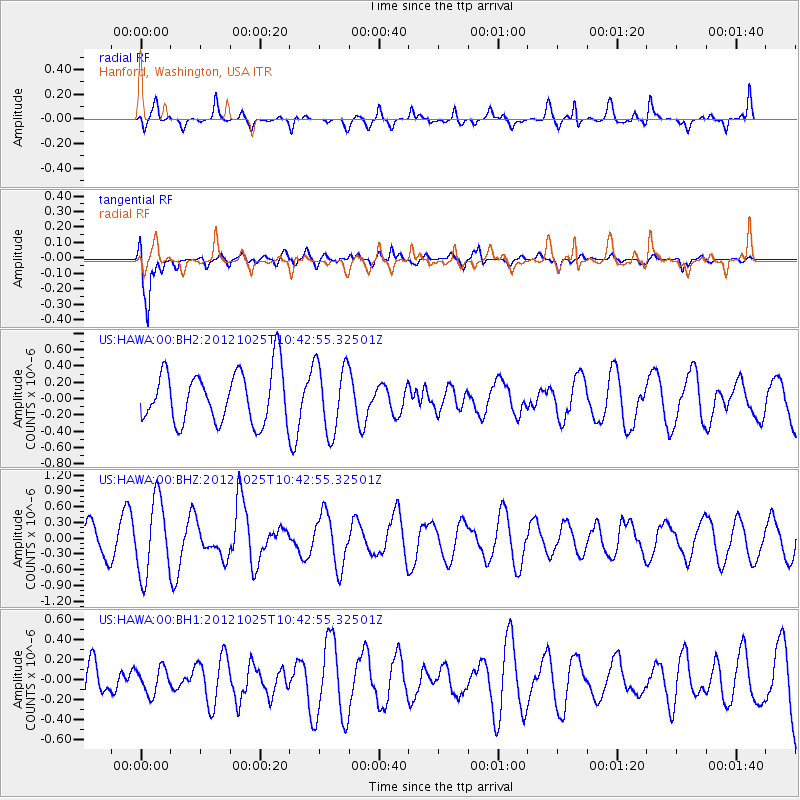
HAWA Hanford, Washington, USA - Earthquake Result Viewer
*The percent match for this event was below the threshold and hence no stack was calculated.
| Earthquake location: |
Near East Coast Of Honshu, Japan |
| Earthquake latitude/longitude: |
38.3/141.7 |
| Earthquake time(UTC): |
2012/10/25 (299) 10:32:28 GMT |
| Earthquake Depth: |
56 km |
| Earthquake Magnitude: |
5.5 MB, 5.6 MW, 5.7 MW |
| Earthquake Catalog/Contributor: |
WHDF/NEIC |
|
| Network: |
US United States National Seismic Network |
| Station: |
HAWA Hanford, Washington, USA |
| Lat/Lon: |
46.39 N/119.53 W |
| Elevation: |
364 m |
|
| Distance: |
68.7 deg |
| Az: |
47.221 deg |
| Baz: |
303.458 deg |
| Ray Param: |
$rayparam |
*The percent match for this event was below the threshold and hence was not used in the summary stack. |
|
| Radial Match: |
51.652977 % |
| Radial Bump: |
381 |
| Transverse Match: |
67.83773 % |
| Transverse Bump: |
400 |
| SOD ConfigId: |
558545 |
| Insert Time: |
2013-09-17 21:44:08.296 +0000 |
| GWidth: |
2.5 |
| Max Bumps: |
400 |
| Tol: |
0.001 |
|
Signal To Noise
| Channel | StoN | STA | LTA |
| US:HAWA:00:BHZ:20121025T10:42:55.32501Z | 1.7813522 | 7.2337747E-7 | 4.0608333E-7 |
| US:HAWA:00:BH1:20121025T10:42:55.32501Z | 0.56481594 | 1.2891164E-7 | 2.2823654E-7 |
| US:HAWA:00:BH2:20121025T10:42:55.32501Z | 1.3354685 | 4.2480832E-7 | 3.1809682E-7 |
| Arrivals |
| Ps | |
| PpPs | |
| PsPs/PpSs | |


