You are here: Home > Network List > US - United States National Seismic Network Stations List
> Station AMTX Amarillo, Texas, USA > Earthquake Result Viewer
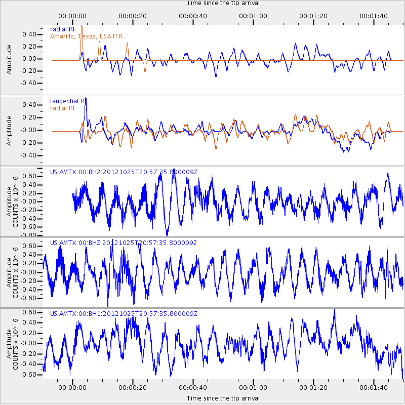
AMTX Amarillo, Texas, USA - Earthquake Result Viewer
*The percent match for this event was below the threshold and hence no stack was calculated.
| Earthquake location: |
Northern Peru |
| Earthquake latitude/longitude: |
-5.9/-76.1 |
| Earthquake time(UTC): |
2012/10/25 (299) 20:49:35 GMT |
| Earthquake Depth: |
24 km |
| Earthquake Magnitude: |
5.5 ML |
| Earthquake Catalog/Contributor: |
NEIC PDE/NEIC PDE-W |
|
| Network: |
US United States National Seismic Network |
| Station: |
AMTX Amarillo, Texas, USA |
| Lat/Lon: |
34.53 N/101.41 W |
| Elevation: |
1010 m |
|
| Distance: |
46.8 deg |
| Az: |
331.015 deg |
| Baz: |
144.278 deg |
| Ray Param: |
$rayparam |
*The percent match for this event was below the threshold and hence was not used in the summary stack. |
|
| Radial Match: |
35.552647 % |
| Radial Bump: |
400 |
| Transverse Match: |
53.018528 % |
| Transverse Bump: |
400 |
| SOD ConfigId: |
558545 |
| Insert Time: |
2013-09-17 21:46:30.018 +0000 |
| GWidth: |
2.5 |
| Max Bumps: |
400 |
| Tol: |
0.001 |
|
Signal To Noise
| Channel | StoN | STA | LTA |
| US:AMTX:00:BHZ:20121025T20:57:35.800009Z | 1.2432178 | 2.5451092E-7 | 2.0471948E-7 |
| US:AMTX:00:BH1:20121025T20:57:35.800009Z | 1.180732 | 2.7312873E-7 | 2.3132152E-7 |
| US:AMTX:00:BH2:20121025T20:57:35.800009Z | 1.8155313 | 4.4058768E-7 | 2.42677E-7 |
| Arrivals |
| Ps | |
| PpPs | |
| PsPs/PpSs | |


