You are here: Home > Network List > CU - Caribbean Network (USGS) Stations List
> Station BBGH Gun Hill, Barbados > Earthquake Result Viewer
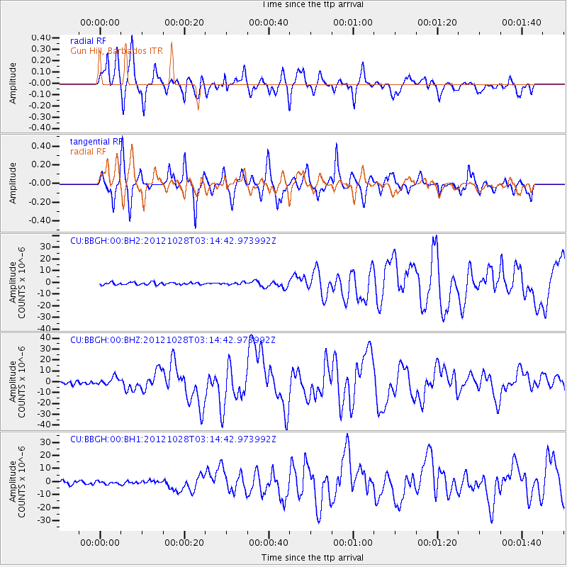
BBGH Gun Hill, Barbados - Earthquake Result Viewer
*The percent match for this event was below the threshold and hence no stack was calculated.
| Earthquake location: |
Queen Charlotte Islands Region |
| Earthquake latitude/longitude: |
52.8/-132.1 |
| Earthquake time(UTC): |
2012/10/28 (302) 03:04:08 GMT |
| Earthquake Depth: |
14 km |
| Earthquake Magnitude: |
6.5 MB, 7.5 MS, 7.8 MW, 7.8 MW |
| Earthquake Catalog/Contributor: |
WHDF/NEIC |
|
| Network: |
CU Caribbean Network (USGS) |
| Station: |
BBGH Gun Hill, Barbados |
| Lat/Lon: |
13.14 N/59.56 W |
| Elevation: |
180 m |
|
| Distance: |
69.1 deg |
| Az: |
95.834 deg |
| Baz: |
321.667 deg |
| Ray Param: |
$rayparam |
*The percent match for this event was below the threshold and hence was not used in the summary stack. |
|
| Radial Match: |
82.054115 % |
| Radial Bump: |
400 |
| Transverse Match: |
82.81509 % |
| Transverse Bump: |
400 |
| SOD ConfigId: |
558545 |
| Insert Time: |
2013-09-17 21:47:58.701 +0000 |
| GWidth: |
2.5 |
| Max Bumps: |
400 |
| Tol: |
0.001 |
|
Signal To Noise
| Channel | StoN | STA | LTA |
| CU:BBGH:00:BHZ:20121028T03:14:42.973992Z | 3.61422 | 3.8189264E-6 | 1.0566391E-6 |
| CU:BBGH:00:BH1:20121028T03:14:42.973992Z | 1.0324752 | 1.0734952E-6 | 1.0397298E-6 |
| CU:BBGH:00:BH2:20121028T03:14:42.973992Z | 0.90034443 | 9.157135E-7 | 1.0170702E-6 |
| Arrivals |
| Ps | |
| PpPs | |
| PsPs/PpSs | |


