You are here: Home > Network List > UW - Pacific Northwest Regional Seismic Network Stations List
> Station YACT Amboy, WA, USA > Earthquake Result Viewer
YACT Amboy, WA, USA - Earthquake Result Viewer
| Earthquake location: |
East Of Kuril Islands |
| Earthquake latitude/longitude: |
46.9/155.2 |
| Earthquake time(UTC): |
2009/01/15 (015) 17:49:39 GMT |
| Earthquake Depth: |
36 km |
| Earthquake Magnitude: |
6.9 MB, 7.5 MS, 7.4 MW, 7.4 MW |
| Earthquake Catalog/Contributor: |
WHDF/NEIC |
|
| Network: |
UW Pacific Northwest Regional Seismic Network |
| Station: |
YACT Amboy, WA, USA |
| Lat/Lon: |
45.93 N/122.42 W |
| Elevation: |
211 m |
|
| Distance: |
54.3 deg |
| Az: |
58.462 deg |
| Baz: |
303.064 deg |
| Ray Param: |
0.065489404 |
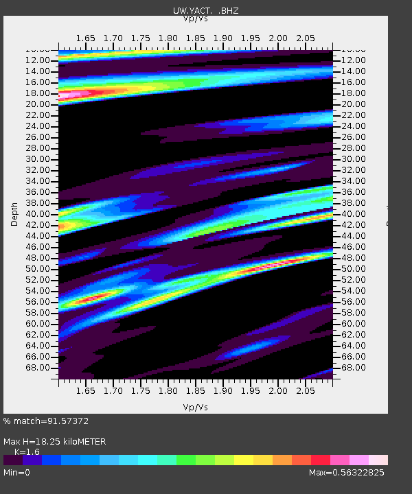
| Estimated Moho Depth: |
18.25 km |
| Estimated Crust Vp/Vs: |
1.60 |
| Assumed Crust Vp: |
6.566 km/s |
| Estimated Crust Vs: |
4.104 km/s |
| Estimated Crust Poisson's Ratio: |
0.18 |
|
| Radial Match: |
91.57372 % |
| Radial Bump: |
400 |
| Transverse Match: |
88.65894 % |
| Transverse Bump: |
400 |
| SOD ConfigId: |
2834 |
| Insert Time: |
2010-02-27 05:21:44.173 +0000 |
| GWidth: |
2.5 |
| Max Bumps: |
400 |
| Tol: |
0.001 |
|
Signal To Noise
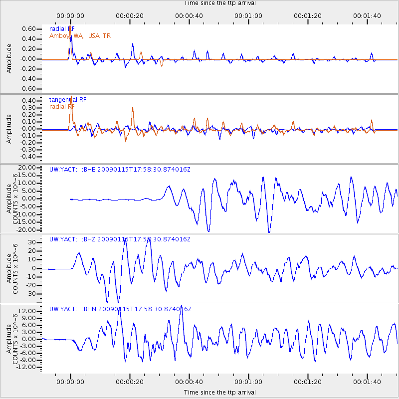
| Channel | StoN | STA | LTA |
| UW:YACT: :BHZ:20090115T17:58:30.874016Z | 53.85483 | 9.984606E-6 | 1.8539852E-7 |
| UW:YACT: :BHN:20090115T17:58:30.874016Z | 6.186338 | 2.5402849E-6 | 4.1062822E-7 |
| UW:YACT: :BHE:20090115T17:58:30.874016Z | 19.256145 | 4.6769487E-6 | 2.4288082E-7 |
| Arrivals |
| Ps | 1.8 SECOND |
| PpPs | 6.8 SECOND |
| PsPs/PpSs | 8.6 SECOND |


