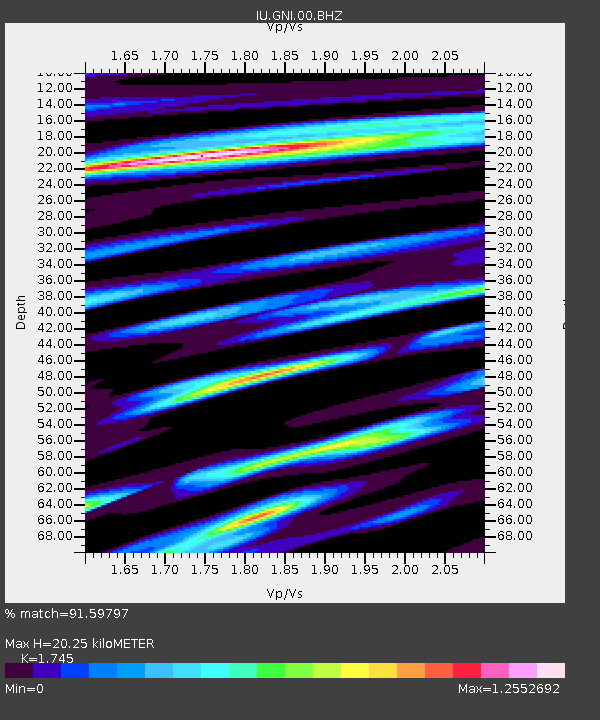
GNI Garni, Armenia - Earthquake Result Viewer
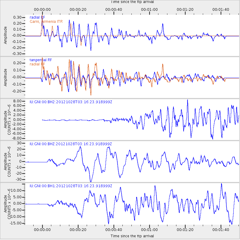
Earthquake location: Queen Charlotte Islands Region
Earthquake latitude/longitude: 52.8/-132.1
Earthquake time(UTC): 2012/10/28 (302) 03:04:08 GMT
Earthquake Depth: 14 km
Earthquake Magnitude: 6.5 MB, 7.5 MS, 7.8 MW, 7.8 MW
Earthquake Catalog/Contributor: WHDF/NEIC
Network: IU Global Seismograph Network (GSN - IRIS/USGS)
Station: GNI Garni, Armenia
Lat/Lon: 40.15 N/44.74 E
Elevation: 1609 m
Distance: 87.4 deg
Az: 2.423 deg
Baz: 358.081 deg
Ray Param: 0.04334655
Estimated Moho Depth: 20.25 km
Estimated Crust Vp/Vs: 1.75
Assumed Crust Vp: 6.291 km/s
Estimated Crust Vs: 3.605 km/s
Estimated Crust Poisson's Ratio: 0.26
Radial Match: 91.59797 %
Radial Bump: 400
Transverse Match: 88.233315 %
Transverse Bump: 400
SOD ConfigId: 558545
Insert Time: 2013-09-17 21:49:09.244 +0000
GWidth: 2.5
Max Bumps: 400
Tol: 0.001

Signal To Noise

ChannelStoNSTALTA
IU:GNI:00:BHZ:20121028T03:16:23.918999Z11.0434151.7184028E-61.5560428E-7
IU:GNI:00:BH1:20121028T03:16:23.918999Z4.23923875.0728625E-71.1966446E-7
IU:GNI:00:BH2:20121028T03:16:23.918999Z1.47906331.3533507E-79.150053E-8
Arrivals
Ps2.5 SECOND
PpPs8.6 SECOND
PsPs/PpSs11 SECOND