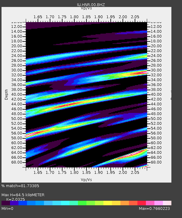
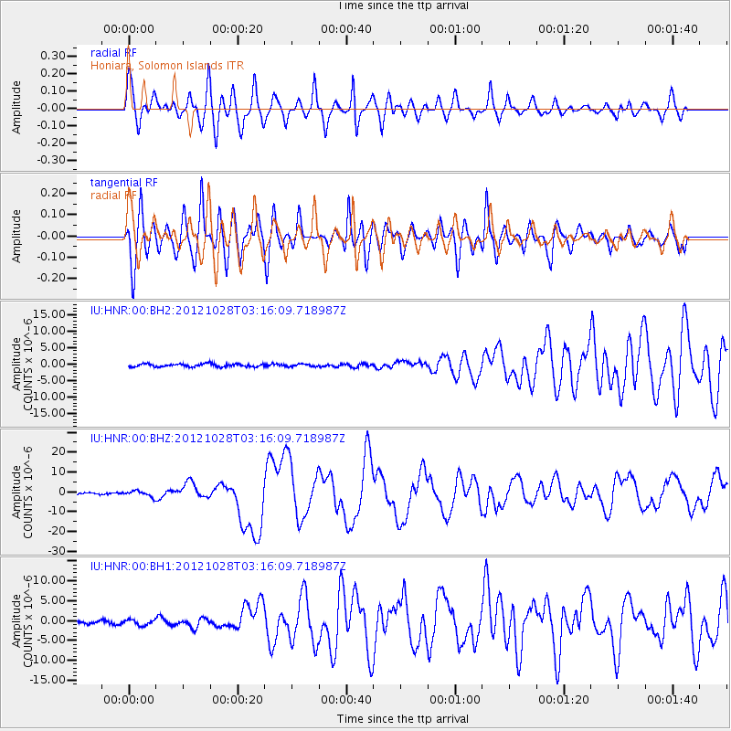
HNR Honiara, Solomon Islands - Earthquake Result Viewer

Earthquake location: Queen Charlotte Islands Region
Earthquake latitude/longitude: 52.8/-132.1
Earthquake time(UTC): 2012/10/28 (302) 03:04:08 GMT
Earthquake Depth: 14 km
Earthquake Magnitude: 6.5 MB, 7.5 MS, 7.8 MW, 7.8 MW
Earthquake Catalog/Contributor: WHDF/NEIC
Network: IU Global Seismograph Network (GSN - IRIS/USGS)
Station: HNR Honiara, Solomon Islands
Lat/Lon: 9.44 S/159.95 E
Elevation: 100 m
Distance: 84.5 deg
Az: 246.734 deg
Baz: 34.438 deg
Ray Param: 0.045417666
Estimated Moho Depth: 64.5 km
Estimated Crust Vp/Vs: 2.03
Assumed Crust Vp: 6.183 km/s
Estimated Crust Vs: 3.042 km/s
Estimated Crust Poisson's Ratio: 0.34
Radial Match: 81.73385 %
Radial Bump: 400
Transverse Match: 89.73699 %
Transverse Bump: 400
SOD ConfigId: 558545
Insert Time: 2013-09-17 21:49:15.237 +0000
GWidth: 2.5
Max Bumps: 400
Tol: 0.001

Signal To Noise

ChannelStoNSTALTA
IU:HNR:00:BHZ:20121028T03:16:09.718987Z4.54333971.4484242E-63.1880165E-7
IU:HNR:00:BH1:20121028T03:16:09.718987Z2.33362176.741976E-72.8890614E-7
IU:HNR:00:BH2:20121028T03:16:09.718987Z0.85675773.8215572E-74.4604877E-7
Arrivals
Ps11 SECOND
PpPs31 SECOND
PsPs/PpSs42 SECOND