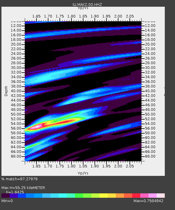
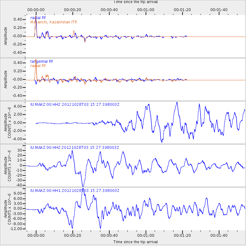
MAKZ Makanchi, Kazakhstan - Earthquake Result Viewer

Earthquake location: Queen Charlotte Islands Region
Earthquake latitude/longitude: 52.8/-132.1
Earthquake time(UTC): 2012/10/28 (302) 03:04:08 GMT
Earthquake Depth: 14 km
Earthquake Magnitude: 6.5 MB, 7.5 MS, 7.8 MW, 7.8 MW
Earthquake Catalog/Contributor: WHDF/NEIC
Network: IU Global Seismograph Network (GSN - IRIS/USGS)
Station: MAKZ Makanchi, Kazakhstan
Lat/Lon: 46.81 N/81.98 E
Elevation: 600 m
Distance: 76.6 deg
Az: 336.693 deg
Baz: 20.477 deg
Ray Param: 0.05088146
Estimated Moho Depth: 55.25 km
Estimated Crust Vp/Vs: 1.64
Assumed Crust Vp: 6.571 km/s
Estimated Crust Vs: 4.0 km/s
Estimated Crust Poisson's Ratio: 0.21
Radial Match: 97.27979 %
Radial Bump: 275
Transverse Match: 93.97753 %
Transverse Bump: 319
SOD ConfigId: 558545
Insert Time: 2013-09-17 21:49:43.631 +0000
GWidth: 2.5
Max Bumps: 400
Tol: 0.001

Signal To Noise

ChannelStoNSTALTA
IU:MAKZ:00:HHZ:20121028T03:15:27.398003Z19.6737882.5769816E-61.3098553E-7
IU:MAKZ:00:HH1:20121028T03:15:27.398003Z4.4396071.0542442E-62.374634E-7
IU:MAKZ:00:HH2:20121028T03:15:27.398003Z2.2361231.7452682E-77.804884E-8
Arrivals
Ps5.6 SECOND
PpPs21 SECOND
PsPs/PpSs27 SECOND