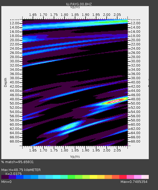
PAYG Puerto Ayora, Galapagos Islands - Earthquake Result Viewer
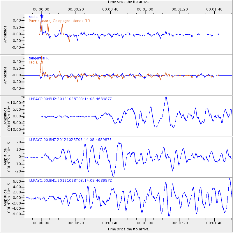
Earthquake location: Queen Charlotte Islands Region
Earthquake latitude/longitude: 52.8/-132.1
Earthquake time(UTC): 2012/10/28 (302) 03:04:08 GMT
Earthquake Depth: 14 km
Earthquake Magnitude: 6.5 MB, 7.5 MS, 7.8 MW, 7.8 MW
Earthquake Catalog/Contributor: WHDF/NEIC
Network: IU Global Seismograph Network (GSN - IRIS/USGS)
Station: PAYG Puerto Ayora, Galapagos Islands
Lat/Lon: 0.67 S/90.29 W
Elevation: 270 m
Distance: 63.7 deg
Az: 131.947 deg
Baz: 333.144 deg
Ray Param: 0.059409767
Estimated Moho Depth: 48.75 km
Estimated Crust Vp/Vs: 2.04
Assumed Crust Vp: 4.802 km/s
Estimated Crust Vs: 2.357 km/s
Estimated Crust Poisson's Ratio: 0.34
Radial Match: 95.65931 %
Radial Bump: 295
Transverse Match: 90.57631 %
Transverse Bump: 358
SOD ConfigId: 558545
Insert Time: 2013-09-17 21:49:57.081 +0000
GWidth: 2.5
Max Bumps: 400
Tol: 0.001

Signal To Noise

ChannelStoNSTALTA
IU:PAYG:00:BHZ:20121028T03:14:08.468987Z3.67623471.9845972E-65.398451E-7
IU:PAYG:00:BH1:20121028T03:14:08.468987Z1.64424414.740257E-72.8829402E-7
IU:PAYG:00:BH2:20121028T03:14:08.468987Z2.79147659.1452813E-73.276145E-7
Arrivals
Ps11 SECOND
PpPs30 SECOND
PsPs/PpSs41 SECOND