You are here: Home > Network List > US - United States National Seismic Network Stations List
> Station CBN Corbin (Fredericksburg Observatory), Virginia, USA > Earthquake Result Viewer
CBN Corbin (Fredericksburg Observatory), Virginia, USA - Earthquake Result Viewer
| Earthquake location: |
Queen Charlotte Islands Region |
| Earthquake latitude/longitude: |
52.8/-132.1 |
| Earthquake time(UTC): |
2012/10/28 (302) 03:04:08 GMT |
| Earthquake Depth: |
14 km |
| Earthquake Magnitude: |
6.5 MB, 7.5 MS, 7.8 MW, 7.8 MW |
| Earthquake Catalog/Contributor: |
WHDF/NEIC |
|
| Network: |
US United States National Seismic Network |
| Station: |
CBN Corbin (Fredericksburg Observatory), Virginia, USA |
| Lat/Lon: |
38.21 N/77.37 W |
| Elevation: |
70 m |
|
| Distance: |
40.0 deg |
| Az: |
88.873 deg |
| Baz: |
309.577 deg |
| Ray Param: |
0.07461533 |
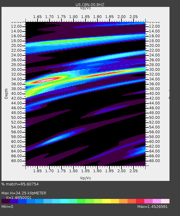
| Estimated Moho Depth: |
34.25 km |
| Estimated Crust Vp/Vs: |
1.69 |
| Assumed Crust Vp: |
6.419 km/s |
| Estimated Crust Vs: |
3.81 km/s |
| Estimated Crust Poisson's Ratio: |
0.23 |
|
| Radial Match: |
95.60754 % |
| Radial Bump: |
344 |
| Transverse Match: |
57.96665 % |
| Transverse Bump: |
400 |
| SOD ConfigId: |
558545 |
| Insert Time: |
2013-09-17 21:51:03.772 +0000 |
| GWidth: |
2.5 |
| Max Bumps: |
400 |
| Tol: |
0.001 |
|
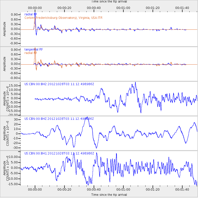
Signal To Noise
| Channel | StoN | STA | LTA |
| US:CBN:00:BHZ:20121028T03:11:12.498986Z | 1.9501767 | 2.9004677E-6 | 1.4872845E-6 |
| US:CBN:00:BH1:20121028T03:11:12.498986Z | 1.3884083 | 1.468794E-6 | 1.0578977E-6 |
| US:CBN:00:BH2:20121028T03:11:12.498986Z | 3.3402598 | 2.1557896E-6 | 6.453958E-7 |
| Arrivals |
| Ps | 3.9 SECOND |
| PpPs | 13 SECOND |
| PsPs/PpSs | 17 SECOND |


