You are here: Home > Network List > US - United States National Seismic Network Stations List
> Station NATX Nacogdoches, Texas, USA > Earthquake Result Viewer
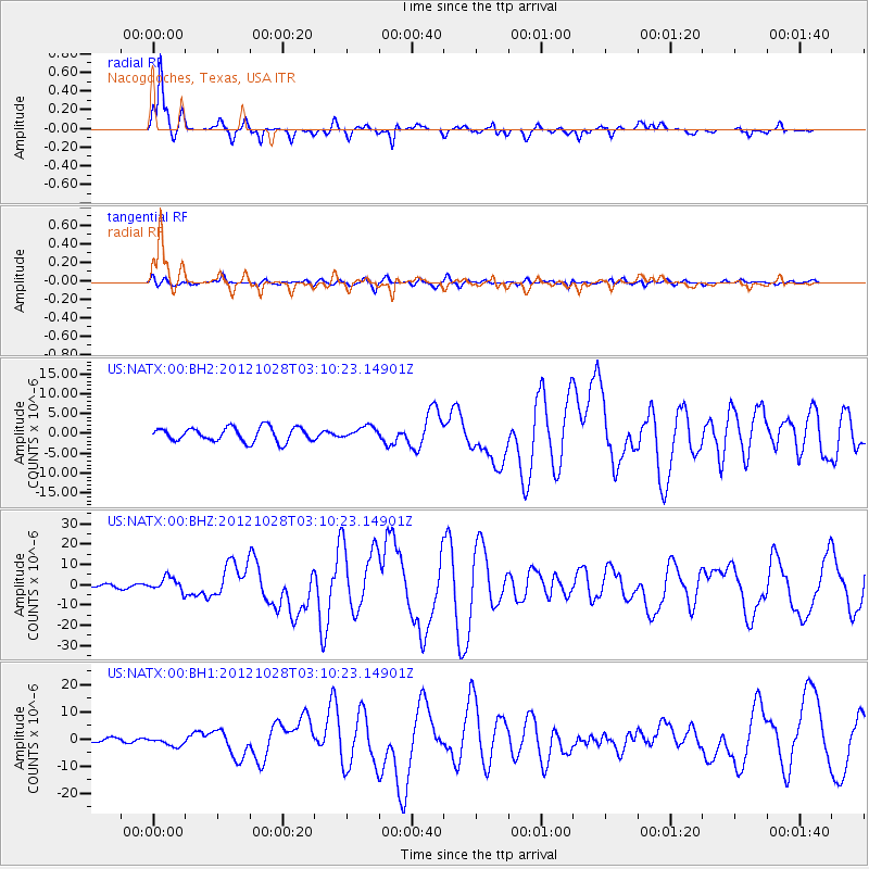
NATX Nacogdoches, Texas, USA - Earthquake Result Viewer
*The percent match for this event was below the threshold and hence no stack was calculated.
| Earthquake location: |
Queen Charlotte Islands Region |
| Earthquake latitude/longitude: |
52.8/-132.1 |
| Earthquake time(UTC): |
2012/10/28 (302) 03:04:08 GMT |
| Earthquake Depth: |
14 km |
| Earthquake Magnitude: |
6.5 MB, 7.5 MS, 7.8 MW, 7.8 MW |
| Earthquake Catalog/Contributor: |
WHDF/NEIC |
|
| Network: |
US United States National Seismic Network |
| Station: |
NATX Nacogdoches, Texas, USA |
| Lat/Lon: |
31.76 N/94.66 W |
| Elevation: |
156 m |
|
| Distance: |
34.2 deg |
| Az: |
112.941 deg |
| Baz: |
318.96 deg |
| Ray Param: |
$rayparam |
*The percent match for this event was below the threshold and hence was not used in the summary stack. |
|
| Radial Match: |
93.19045 % |
| Radial Bump: |
297 |
| Transverse Match: |
77.5303 % |
| Transverse Bump: |
400 |
| SOD ConfigId: |
558545 |
| Insert Time: |
2013-09-17 21:51:45.394 +0000 |
| GWidth: |
2.5 |
| Max Bumps: |
400 |
| Tol: |
0.001 |
|
Signal To Noise
| Channel | StoN | STA | LTA |
| US:NATX:00:BHZ:20121028T03:10:23.14901Z | 6.166409 | 3.3901185E-6 | 5.4977187E-7 |
| US:NATX:00:BH1:20121028T03:10:23.14901Z | 2.1746218 | 1.6799371E-6 | 7.7251923E-7 |
| US:NATX:00:BH2:20121028T03:10:23.14901Z | 0.85804665 | 1.5148308E-6 | 1.7654412E-6 |
| Arrivals |
| Ps | |
| PpPs | |
| PsPs/PpSs | |


