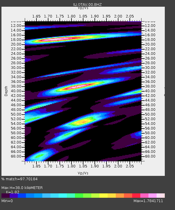
OTAV Otavalo, Ecuador - Earthquake Result Viewer
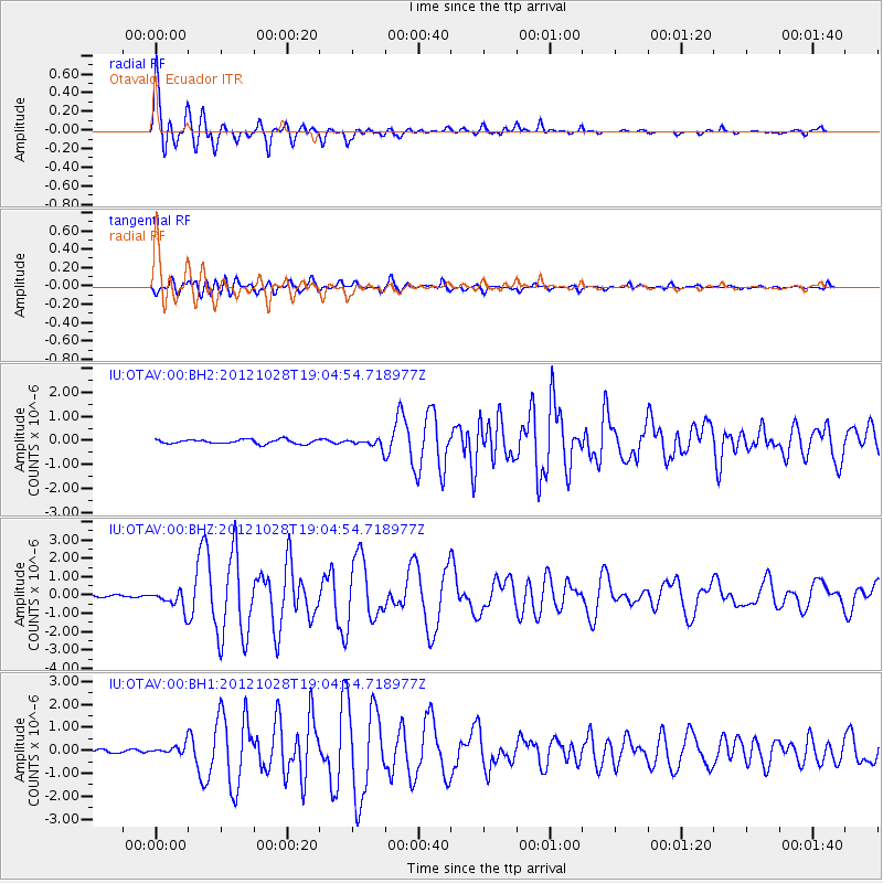
Earthquake location: Queen Charlotte Islands Region
Earthquake latitude/longitude: 52.7/-132.6
Earthquake time(UTC): 2012/10/28 (302) 18:54:20 GMT
Earthquake Depth: 9.0 km
Earthquake Magnitude: 5.9 MB, 6.2 MS, 6.3 MW, 6.3 MW
Earthquake Catalog/Contributor: WHDF/NEIC
Network: IU Global Seismograph Network (GSN - IRIS/USGS)
Station: OTAV Otavalo, Ecuador
Lat/Lon: 0.24 N/78.45 W
Elevation: 3510 m
Distance: 68.9 deg
Az: 119.684 deg
Baz: 328.061 deg
Ray Param: 0.055998884
Estimated Moho Depth: 38.0 km
Estimated Crust Vp/Vs: 1.82
Assumed Crust Vp: 6.472 km/s
Estimated Crust Vs: 3.556 km/s
Estimated Crust Poisson's Ratio: 0.28
Radial Match: 97.70184 %
Radial Bump: 400
Transverse Match: 88.40117 %
Transverse Bump: 400
SOD ConfigId: 558545
Insert Time: 2013-09-17 21:53:31.540 +0000
GWidth: 2.5
Max Bumps: 400
Tol: 0.001

Signal To Noise

ChannelStoNSTALTA
IU:OTAV:00:BHZ:20121028T19:04:54.718977Z8.454635.3905865E-76.375898E-8
IU:OTAV:00:BH1:20121028T19:04:54.718977Z3.41206882.1652988E-76.346E-8
IU:OTAV:00:BH2:20121028T19:04:54.718977Z2.03250531.7619166E-78.6686946E-8
Arrivals
Ps5.0 SECOND
PpPs16 SECOND
PsPs/PpSs21 SECOND