You are here: Home > Network List > UW - Pacific Northwest Regional Seismic Network Stations List
> Station YACT Amboy, WA, USA > Earthquake Result Viewer
YACT Amboy, WA, USA - Earthquake Result Viewer
| Earthquake location: |
Vanuatu Islands |
| Earthquake latitude/longitude: |
-17.8/167.9 |
| Earthquake time(UTC): |
2009/06/02 (153) 02:17:03 GMT |
| Earthquake Depth: |
15 km |
| Earthquake Magnitude: |
5.7 MB, 6.2 MS, 6.3 MW, 6.3 MW |
| Earthquake Catalog/Contributor: |
WHDF/NEIC |
|
| Network: |
UW Pacific Northwest Regional Seismic Network |
| Station: |
YACT Amboy, WA, USA |
| Lat/Lon: |
45.93 N/122.42 W |
| Elevation: |
211 m |
|
| Distance: |
89.2 deg |
| Az: |
40.87 deg |
| Baz: |
243.311 deg |
| Ray Param: |
0.04203311 |
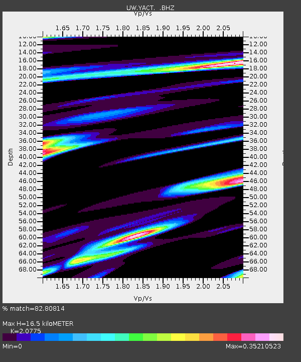
| Estimated Moho Depth: |
16.5 km |
| Estimated Crust Vp/Vs: |
2.08 |
| Assumed Crust Vp: |
6.566 km/s |
| Estimated Crust Vs: |
3.161 km/s |
| Estimated Crust Poisson's Ratio: |
0.35 |
|
| Radial Match: |
82.80814 % |
| Radial Bump: |
400 |
| Transverse Match: |
60.969864 % |
| Transverse Bump: |
380 |
| SOD ConfigId: |
2648 |
| Insert Time: |
2010-02-27 05:22:00.377 +0000 |
| GWidth: |
2.5 |
| Max Bumps: |
400 |
| Tol: |
0.001 |
|

Signal To Noise
| Channel | StoN | STA | LTA |
| UW:YACT: :BHZ:20090602T02:29:26.874014Z | 2.6869483 | 5.146786E-7 | 1.9154764E-7 |
| UW:YACT: :BHN:20090602T02:29:26.874014Z | 0.74818385 | 1.1483939E-7 | 1.5349087E-7 |
| UW:YACT: :BHE:20090602T02:29:26.874014Z | 1.006597 | 1.267192E-7 | 1.2588872E-7 |
| Arrivals |
| Ps | 2.8 SECOND |
| PpPs | 7.6 SECOND |
| PsPs/PpSs | 10 SECOND |


