You are here: Home > Network List > US - United States National Seismic Network Stations List
> Station HDIL Hopedale, Illinois, USA > Earthquake Result Viewer
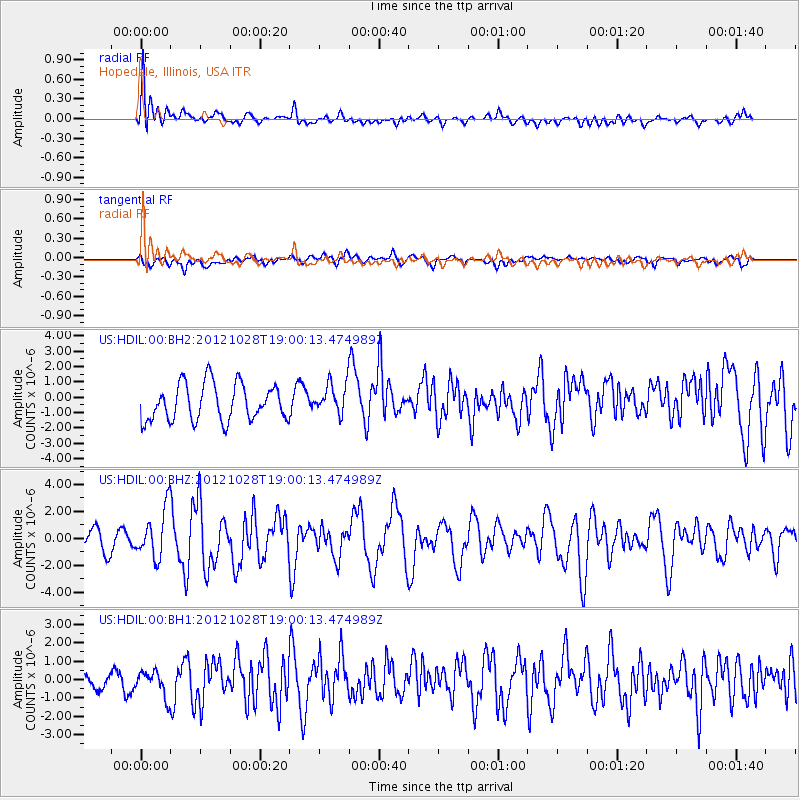
HDIL Hopedale, Illinois, USA - Earthquake Result Viewer
*The percent match for this event was below the threshold and hence no stack was calculated.
| Earthquake location: |
Queen Charlotte Islands Region |
| Earthquake latitude/longitude: |
52.7/-132.6 |
| Earthquake time(UTC): |
2012/10/28 (302) 18:54:20 GMT |
| Earthquake Depth: |
9.0 km |
| Earthquake Magnitude: |
5.9 MB, 6.2 MS, 6.3 MW, 6.3 MW |
| Earthquake Catalog/Contributor: |
WHDF/NEIC |
|
| Network: |
US United States National Seismic Network |
| Station: |
HDIL Hopedale, Illinois, USA |
| Lat/Lon: |
40.56 N/89.29 W |
| Elevation: |
219 m |
|
| Distance: |
31.6 deg |
| Az: |
94.966 deg |
| Baz: |
307.232 deg |
| Ray Param: |
$rayparam |
*The percent match for this event was below the threshold and hence was not used in the summary stack. |
|
| Radial Match: |
74.81241 % |
| Radial Bump: |
400 |
| Transverse Match: |
67.48186 % |
| Transverse Bump: |
400 |
| SOD ConfigId: |
558545 |
| Insert Time: |
2013-09-17 21:54:32.071 +0000 |
| GWidth: |
2.5 |
| Max Bumps: |
400 |
| Tol: |
0.001 |
|
Signal To Noise
| Channel | StoN | STA | LTA |
| US:HDIL:00:BHZ:20121028T19:00:13.474989Z | 2.2235982 | 1.8310934E-6 | 8.2348214E-7 |
| US:HDIL:00:BH1:20121028T19:00:13.474989Z | 1.327179 | 6.843994E-7 | 5.156798E-7 |
| US:HDIL:00:BH2:20121028T19:00:13.474989Z | 0.8398182 | 9.966416E-7 | 1.186735E-6 |
| Arrivals |
| Ps | |
| PpPs | |
| PsPs/PpSs | |


