You are here: Home > Network List > UW - Pacific Northwest Regional Seismic Network Stations List
> Station YACT Amboy, WA, USA > Earthquake Result Viewer
YACT Amboy, WA, USA - Earthquake Result Viewer
| Earthquake location: |
North Of Svalbard |
| Earthquake latitude/longitude: |
80.3/-1.9 |
| Earthquake time(UTC): |
2009/03/06 (065) 10:50:29 GMT |
| Earthquake Depth: |
9.0 km |
| Earthquake Magnitude: |
6.6 MB, 6.5 MS, 6.5 MW, 6.4 MW |
| Earthquake Catalog/Contributor: |
WHDF/NEIC |
|
| Network: |
UW Pacific Northwest Regional Seismic Network |
| Station: |
YACT Amboy, WA, USA |
| Lat/Lon: |
45.93 N/122.42 W |
| Elevation: |
211 m |
|
| Distance: |
49.8 deg |
| Az: |
308.086 deg |
| Baz: |
10.999 deg |
| Ray Param: |
0.06848981 |
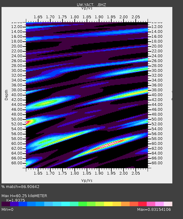
| Estimated Moho Depth: |
60.25 km |
| Estimated Crust Vp/Vs: |
1.94 |
| Assumed Crust Vp: |
6.566 km/s |
| Estimated Crust Vs: |
3.389 km/s |
| Estimated Crust Poisson's Ratio: |
0.32 |
|
| Radial Match: |
86.90642 % |
| Radial Bump: |
400 |
| Transverse Match: |
72.51251 % |
| Transverse Bump: |
400 |
| SOD ConfigId: |
2658 |
| Insert Time: |
2010-02-27 05:22:11.654 +0000 |
| GWidth: |
2.5 |
| Max Bumps: |
400 |
| Tol: |
0.001 |
|
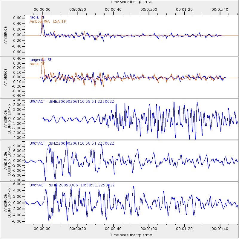
Signal To Noise
| Channel | StoN | STA | LTA |
| UW:YACT: :BHZ:20090306T10:58:51.225002Z | 14.444041 | 6.1026394E-6 | 4.225022E-7 |
| UW:YACT: :BHN:20090306T10:58:51.225002Z | 10.558101 | 2.9489306E-6 | 2.7930506E-7 |
| UW:YACT: :BHE:20090306T10:58:51.225002Z | 1.6674713 | 5.971487E-7 | 3.5811632E-7 |
| Arrivals |
| Ps | 9.1 SECOND |
| PpPs | 25 SECOND |
| PsPs/PpSs | 35 SECOND |


