You are here: Home > Network List > UW - Pacific Northwest Regional Seismic Network Stations List
> Station YACT Amboy, WA, USA > Earthquake Result Viewer
YACT Amboy, WA, USA - Earthquake Result Viewer
| Earthquake location: |
Kuril Islands |
| Earthquake latitude/longitude: |
50.8/155.0 |
| Earthquake time(UTC): |
2009/04/21 (111) 05:26:11 GMT |
| Earthquake Depth: |
152 km |
| Earthquake Magnitude: |
6.0 MB, 6.2 MW, 6.2 MW |
| Earthquake Catalog/Contributor: |
WHDF/NEIC |
|
| Network: |
UW Pacific Northwest Regional Seismic Network |
| Station: |
YACT Amboy, WA, USA |
| Lat/Lon: |
45.93 N/122.42 W |
| Elevation: |
211 m |
|
| Distance: |
52.3 deg |
| Az: |
60.951 deg |
| Baz: |
307.41 deg |
| Ray Param: |
0.06630577 |
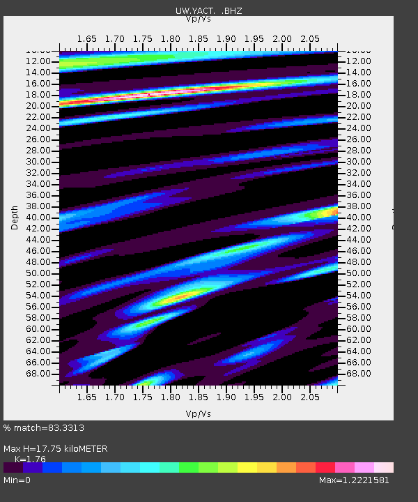
| Estimated Moho Depth: |
17.75 km |
| Estimated Crust Vp/Vs: |
1.76 |
| Assumed Crust Vp: |
6.566 km/s |
| Estimated Crust Vs: |
3.731 km/s |
| Estimated Crust Poisson's Ratio: |
0.26 |
|
| Radial Match: |
83.3313 % |
| Radial Bump: |
400 |
| Transverse Match: |
64.34215 % |
| Transverse Bump: |
400 |
| SOD ConfigId: |
2658 |
| Insert Time: |
2010-02-27 05:22:14.756 +0000 |
| GWidth: |
2.5 |
| Max Bumps: |
400 |
| Tol: |
0.001 |
|

Signal To Noise
| Channel | StoN | STA | LTA |
| UW:YACT: :BHZ:20090421T05:34:37.150005Z | 9.922961 | 1.7663181E-6 | 1.7800312E-7 |
| UW:YACT: :BHN:20090421T05:34:37.150005Z | 3.9622068 | 6.354676E-7 | 1.6038223E-7 |
| UW:YACT: :BHE:20090421T05:34:37.150005Z | 5.736173 | 7.271126E-7 | 1.2675918E-7 |
| Arrivals |
| Ps | 2.2 SECOND |
| PpPs | 7.0 SECOND |
| PsPs/PpSs | 9.2 SECOND |


