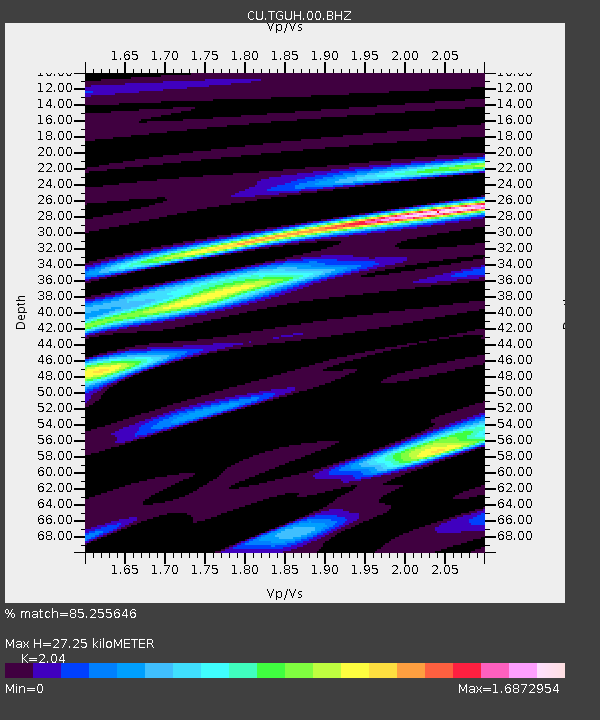
TGUH Tegucigalpa, Honduras - Earthquake Result Viewer

Earthquake location: Queen Charlotte Islands Region
Earthquake latitude/longitude: 52.4/-131.9
Earthquake time(UTC): 2012/10/30 (304) 02:49:02 GMT
Earthquake Depth: 9.0 km
Earthquake Magnitude: 5.8 MB, 6.0 MS, 6.2 MW, 6.2 MW
Earthquake Catalog/Contributor: WHDF/NEIC
Network: CU Caribbean Network (USGS)
Station: TGUH Tegucigalpa, Honduras
Lat/Lon: 14.06 N/87.27 W
Elevation: 0.0 m
Distance: 52.1 deg
Az: 120.248 deg
Baz: 326.917 deg
Ray Param: 0.06697237
Estimated Moho Depth: 27.25 km
Estimated Crust Vp/Vs: 2.04
Assumed Crust Vp: 6.597 km/s
Estimated Crust Vs: 3.234 km/s
Estimated Crust Poisson's Ratio: 0.34
Radial Match: 85.255646 %
Radial Bump: 400
Transverse Match: 78.252655 %
Transverse Bump: 400
SOD ConfigId: 558545
Insert Time: 2013-09-17 22:01:01.622 +0000
GWidth: 2.5
Max Bumps: 400
Tol: 0.001

Signal To Noise

ChannelStoNSTALTA
CU:TGUH:00:BHZ:20121030T02:57:41.649028Z8.73664959.874827E-71.1302762E-7
CU:TGUH:00:BH1:20121030T02:57:41.649028Z3.5466074.491572E-71.2664421E-7
CU:TGUH:00:BH2:20121030T02:57:41.649028Z2.65546774.047561E-71.5242365E-7
Arrivals
Ps4.5 SECOND
PpPs12 SECOND
PsPs/PpSs16 SECOND