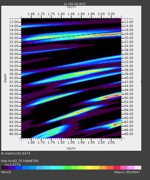
GNI Garni, Armenia - Earthquake Result Viewer
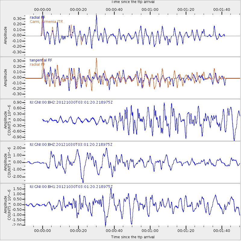
Earthquake location: Queen Charlotte Islands Region
Earthquake latitude/longitude: 52.4/-131.9
Earthquake time(UTC): 2012/10/30 (304) 02:49:02 GMT
Earthquake Depth: 9.0 km
Earthquake Magnitude: 5.8 MB, 6.0 MS, 6.2 MW, 6.2 MW
Earthquake Catalog/Contributor: WHDF/NEIC
Network: IU Global Seismograph Network (GSN - IRIS/USGS)
Station: GNI Garni, Armenia
Lat/Lon: 40.15 N/44.74 E
Elevation: 1609 m
Distance: 87.8 deg
Az: 2.574 deg
Baz: 357.941 deg
Ray Param: 0.043050274
Estimated Moho Depth: 62.75 km
Estimated Crust Vp/Vs: 2.08
Assumed Crust Vp: 6.291 km/s
Estimated Crust Vs: 3.028 km/s
Estimated Crust Poisson's Ratio: 0.35
Radial Match: 82.8474 %
Radial Bump: 400
Transverse Match: 81.3358 %
Transverse Bump: 400
SOD ConfigId: 558545
Insert Time: 2013-09-17 22:01:54.405 +0000
GWidth: 2.5
Max Bumps: 400
Tol: 0.001

Signal To Noise

ChannelStoNSTALTA
IU:GNI:00:BHZ:20121030T03:01:20.218975Z7.38611945.366315E-77.265405E-8
IU:GNI:00:BH1:20121030T03:01:20.218975Z2.04461121.2802668E-76.2616635E-8
IU:GNI:00:BH2:20121030T03:01:20.218975Z1.45953951.270574E-78.705308E-8
Arrivals
Ps11 SECOND
PpPs30 SECOND
PsPs/PpSs41 SECOND