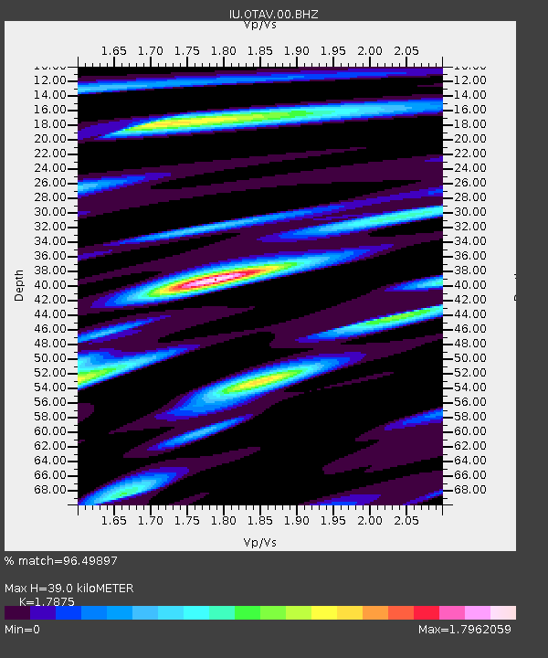
OTAV Otavalo, Ecuador - Earthquake Result Viewer
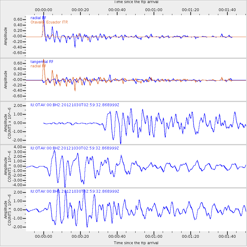
Earthquake location: Queen Charlotte Islands Region
Earthquake latitude/longitude: 52.4/-131.9
Earthquake time(UTC): 2012/10/30 (304) 02:49:02 GMT
Earthquake Depth: 9.0 km
Earthquake Magnitude: 5.8 MB, 6.0 MS, 6.2 MW, 6.2 MW
Earthquake Catalog/Contributor: WHDF/NEIC
Network: IU Global Seismograph Network (GSN - IRIS/USGS)
Station: OTAV Otavalo, Ecuador
Lat/Lon: 0.24 N/78.45 W
Elevation: 3510 m
Distance: 68.4 deg
Az: 120.217 deg
Baz: 328.002 deg
Ray Param: 0.056342483
Estimated Moho Depth: 39.0 km
Estimated Crust Vp/Vs: 1.79
Assumed Crust Vp: 6.472 km/s
Estimated Crust Vs: 3.621 km/s
Estimated Crust Poisson's Ratio: 0.27
Radial Match: 96.49897 %
Radial Bump: 400
Transverse Match: 92.68891 %
Transverse Bump: 400
SOD ConfigId: 558545
Insert Time: 2013-09-17 22:02:41.251 +0000
GWidth: 2.5
Max Bumps: 400
Tol: 0.001

Signal To Noise

ChannelStoNSTALTA
IU:OTAV:00:BHZ:20121030T02:59:32.868999Z11.3346279.782889E-78.6309754E-8
IU:OTAV:00:BH1:20121030T02:59:32.868999Z6.8715724.673382E-76.801037E-8
IU:OTAV:00:BH2:20121030T02:59:32.868999Z6.88113553.9565782E-75.7498916E-8
Arrivals
Ps4.9 SECOND
PpPs16 SECOND
PsPs/PpSs21 SECOND