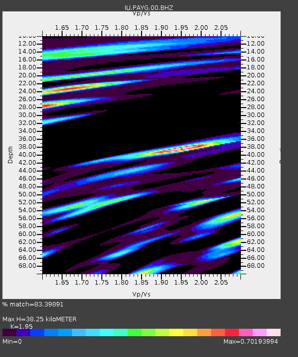
PAYG Puerto Ayora, Galapagos Islands - Earthquake Result Viewer
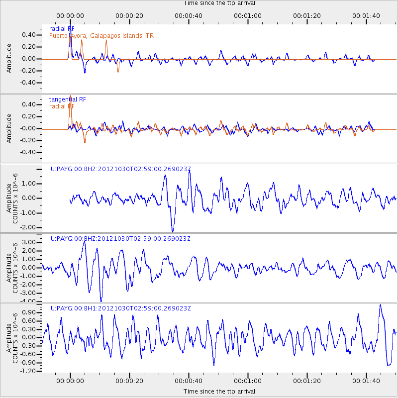
Earthquake location: Queen Charlotte Islands Region
Earthquake latitude/longitude: 52.4/-131.9
Earthquake time(UTC): 2012/10/30 (304) 02:49:02 GMT
Earthquake Depth: 9.0 km
Earthquake Magnitude: 5.8 MB, 6.0 MS, 6.2 MW, 6.2 MW
Earthquake Catalog/Contributor: WHDF/NEIC
Network: IU Global Seismograph Network (GSN - IRIS/USGS)
Station: PAYG Puerto Ayora, Galapagos Islands
Lat/Lon: 0.67 S/90.29 W
Elevation: 270 m
Distance: 63.3 deg
Az: 131.988 deg
Baz: 332.883 deg
Ray Param: 0.059662454
Estimated Moho Depth: 38.25 km
Estimated Crust Vp/Vs: 1.95
Assumed Crust Vp: 4.802 km/s
Estimated Crust Vs: 2.463 km/s
Estimated Crust Poisson's Ratio: 0.32
Radial Match: 83.39891 %
Radial Bump: 400
Transverse Match: 68.66681 %
Transverse Bump: 400
SOD ConfigId: 558545
Insert Time: 2013-09-17 22:02:49.156 +0000
GWidth: 2.5
Max Bumps: 400
Tol: 0.001

Signal To Noise

ChannelStoNSTALTA
IU:PAYG:00:BHZ:20121030T02:59:00.269023Z4.91256571.4953317E-63.0438918E-7
IU:PAYG:00:BH1:20121030T02:59:00.269023Z0.78537442.087305E-72.6577197E-7
IU:PAYG:00:BH2:20121030T02:59:00.269023Z4.73537251.0594075E-62.2372211E-7
Arrivals
Ps7.7 SECOND
PpPs23 SECOND
PsPs/PpSs31 SECOND