You are here: Home > Network List > US - United States National Seismic Network Stations List
> Station MIAR Mount Ida, Arkansas, USA > Earthquake Result Viewer
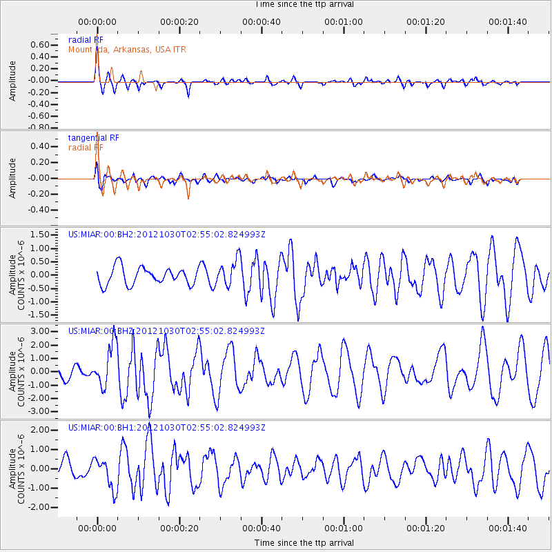
MIAR Mount Ida, Arkansas, USA - Earthquake Result Viewer
*The percent match for this event was below the threshold and hence no stack was calculated.
| Earthquake location: |
Queen Charlotte Islands Region |
| Earthquake latitude/longitude: |
52.4/-131.9 |
| Earthquake time(UTC): |
2012/10/30 (304) 02:49:02 GMT |
| Earthquake Depth: |
9.0 km |
| Earthquake Magnitude: |
5.8 MB, 6.0 MS, 6.2 MW, 6.2 MW |
| Earthquake Catalog/Contributor: |
WHDF/NEIC |
|
| Network: |
US United States National Seismic Network |
| Station: |
MIAR Mount Ida, Arkansas, USA |
| Lat/Lon: |
34.55 N/93.58 W |
| Elevation: |
207 m |
|
| Distance: |
32.5 deg |
| Az: |
107.906 deg |
| Baz: |
315.018 deg |
| Ray Param: |
$rayparam |
*The percent match for this event was below the threshold and hence was not used in the summary stack. |
|
| Radial Match: |
70.44787 % |
| Radial Bump: |
357 |
| Transverse Match: |
68.02405 % |
| Transverse Bump: |
400 |
| SOD ConfigId: |
558545 |
| Insert Time: |
2013-09-17 22:04:12.371 +0000 |
| GWidth: |
2.5 |
| Max Bumps: |
400 |
| Tol: |
0.001 |
|
Signal To Noise
| Channel | StoN | STA | LTA |
| US:MIAR:00:BHZ:20121030T02:55:02.824993Z | 2.8266826 | 1.6790949E-6 | 5.9401606E-7 |
| US:MIAR:00:BH1:20121030T02:55:02.824993Z | 1.9898062 | 8.282037E-7 | 4.1622332E-7 |
| US:MIAR:00:BH2:20121030T02:55:02.824993Z | 1.5680152 | 5.0117643E-7 | 3.1962472E-7 |
| Arrivals |
| Ps | |
| PpPs | |
| PsPs/PpSs | |


