You are here: Home > Network List > II - Global Seismograph Network (GSN - IRIS/IDA) Stations List
> Station PALK Pallekele, Sri Lanka > Earthquake Result Viewer
PALK Pallekele, Sri Lanka - Earthquake Result Viewer
| Earthquake location: |
Mindanao, Philippines |
| Earthquake latitude/longitude: |
9.2/126.2 |
| Earthquake time(UTC): |
2012/11/02 (307) 18:17:32 GMT |
| Earthquake Depth: |
37 km |
| Earthquake Magnitude: |
6.2 MB, 5.7 MS, 6.1 MW, 6.1 MW |
| Earthquake Catalog/Contributor: |
WHDF/NEIC |
|
| Network: |
II Global Seismograph Network (GSN - IRIS/IDA) |
| Station: |
PALK Pallekele, Sri Lanka |
| Lat/Lon: |
7.27 N/80.70 E |
| Elevation: |
460 m |
|
| Distance: |
45.0 deg |
| Az: |
271.086 deg |
| Baz: |
84.253 deg |
| Ray Param: |
0.07147866 |
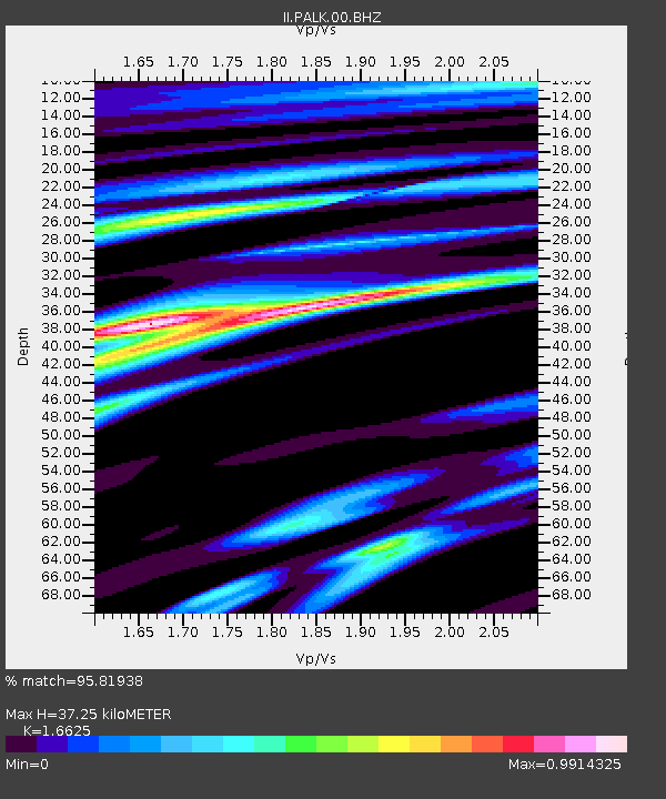
| Estimated Moho Depth: |
37.25 km |
| Estimated Crust Vp/Vs: |
1.66 |
| Assumed Crust Vp: |
6.545 km/s |
| Estimated Crust Vs: |
3.937 km/s |
| Estimated Crust Poisson's Ratio: |
0.22 |
|
| Radial Match: |
95.81938 % |
| Radial Bump: |
322 |
| Transverse Match: |
87.145615 % |
| Transverse Bump: |
400 |
| SOD ConfigId: |
558545 |
| Insert Time: |
2013-09-17 22:15:02.475 +0000 |
| GWidth: |
2.5 |
| Max Bumps: |
400 |
| Tol: |
0.001 |
|
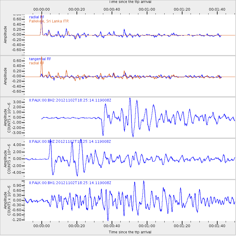
Signal To Noise
| Channel | StoN | STA | LTA |
| II:PALK:00:BHZ:20121102T18:25:14.119008Z | 8.899319 | 1.3000525E-6 | 1.460845E-7 |
| II:PALK:00:BH1:20121102T18:25:14.119008Z | 0.94302756 | 1.0875026E-7 | 1.1532034E-7 |
| II:PALK:00:BH2:20121102T18:25:14.119008Z | 10.309535 | 7.313448E-7 | 7.093868E-8 |
| Arrivals |
| Ps | 4.0 SECOND |
| PpPs | 14 SECOND |
| PsPs/PpSs | 18 SECOND |


