You are here: Home > Network List > TA - USArray Transportable Network (new EarthScope stations) Stations List
> Station H17A Grant Village (NPS), Yellowstone Nt. Park, WY, USA > Earthquake Result Viewer
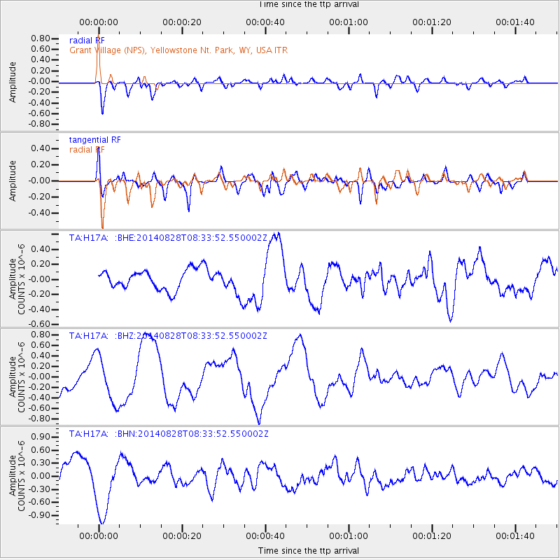
H17A Grant Village (NPS), Yellowstone Nt. Park, WY, USA - Earthquake Result Viewer
*The percent match for this event was below the threshold and hence no stack was calculated.
| Earthquake location: |
Guatemala |
| Earthquake latitude/longitude: |
14.1/-91.9 |
| Earthquake time(UTC): |
2014/08/28 (240) 08:27:41 GMT |
| Earthquake Depth: |
35 km |
| Earthquake Magnitude: |
5.2 MW, 5.2 mb, 5.0 Md, 5.2 Md |
| Earthquake Catalog/Contributor: |
ISC/ISC |
|
| Network: |
TA USArray Transportable Network (new EarthScope stations) |
| Station: |
H17A Grant Village (NPS), Yellowstone Nt. Park, WY, USA |
| Lat/Lon: |
44.40 N/110.58 W |
| Elevation: |
2400 m |
|
| Distance: |
34.1 deg |
| Az: |
335.804 deg |
| Baz: |
146.313 deg |
| Ray Param: |
$rayparam |
*The percent match for this event was below the threshold and hence was not used in the summary stack. |
|
| Radial Match: |
56.466118 % |
| Radial Bump: |
400 |
| Transverse Match: |
44.44471 % |
| Transverse Bump: |
400 |
| SOD ConfigId: |
3390531 |
| Insert Time: |
2019-04-13 16:39:45.320 +0000 |
| GWidth: |
2.5 |
| Max Bumps: |
400 |
| Tol: |
0.001 |
|
Signal To Noise
| Channel | StoN | STA | LTA |
| TA:H17A: :BHZ:20140828T08:33:52.550002Z | 2.4622967 | 4.411993E-7 | 1.7918201E-7 |
| TA:H17A: :BHN:20140828T08:33:52.550002Z | 3.1610284 | 6.9181425E-7 | 2.1885732E-7 |
| TA:H17A: :BHE:20140828T08:33:52.550002Z | 1.4137928 | 1.8041416E-7 | 1.2761004E-7 |
| Arrivals |
| Ps | |
| PpPs | |
| PsPs/PpSs | |


