You are here: Home > Network List > TA - USArray Transportable Network (new EarthScope stations) Stations List
> Station K61A Williamstown, MA, USA > Earthquake Result Viewer
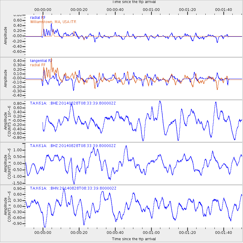
K61A Williamstown, MA, USA - Earthquake Result Viewer
*The percent match for this event was below the threshold and hence no stack was calculated.
| Earthquake location: |
Guatemala |
| Earthquake latitude/longitude: |
14.1/-91.9 |
| Earthquake time(UTC): |
2014/08/28 (240) 08:27:41 GMT |
| Earthquake Depth: |
35 km |
| Earthquake Magnitude: |
5.2 MW, 5.2 mb, 5.0 Md, 5.2 Md |
| Earthquake Catalog/Contributor: |
ISC/ISC |
|
| Network: |
TA USArray Transportable Network (new EarthScope stations) |
| Station: |
K61A Williamstown, MA, USA |
| Lat/Lon: |
42.67 N/73.27 W |
| Elevation: |
391 m |
|
| Distance: |
32.7 deg |
| Az: |
25.849 deg |
| Baz: |
214.996 deg |
| Ray Param: |
$rayparam |
*The percent match for this event was below the threshold and hence was not used in the summary stack. |
|
| Radial Match: |
85.12365 % |
| Radial Bump: |
400 |
| Transverse Match: |
69.78287 % |
| Transverse Bump: |
400 |
| SOD ConfigId: |
3390531 |
| Insert Time: |
2019-04-13 16:39:54.161 +0000 |
| GWidth: |
2.5 |
| Max Bumps: |
400 |
| Tol: |
0.001 |
|
Signal To Noise
| Channel | StoN | STA | LTA |
| TA:K61A: :BHZ:20140828T08:33:39.800002Z | 1.0566759 | 4.3379015E-7 | 4.1052334E-7 |
| TA:K61A: :BHN:20140828T08:33:39.800002Z | 2.597875 | 5.6390877E-7 | 2.1706539E-7 |
| TA:K61A: :BHE:20140828T08:33:39.800002Z | 1.2041684 | 3.2109918E-7 | 2.6665637E-7 |
| Arrivals |
| Ps | |
| PpPs | |
| PsPs/PpSs | |


