You are here: Home > Network List > II - Global Seismograph Network (GSN - IRIS/IDA) Stations List
> Station WRAB Tennant Creek, NT, Australia > Earthquake Result Viewer
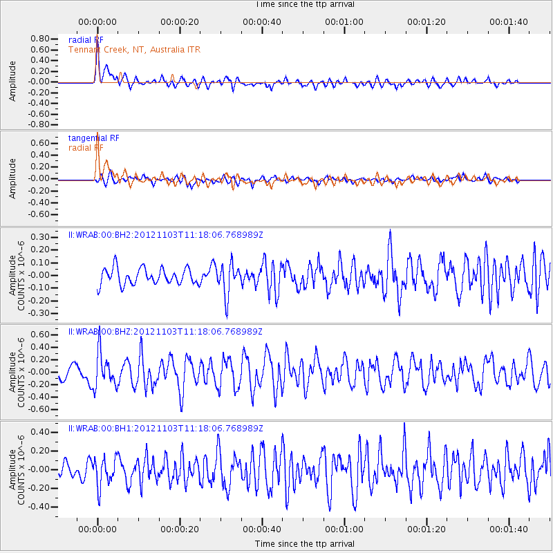
WRAB Tennant Creek, NT, Australia - Earthquake Result Viewer
*The percent match for this event was below the threshold and hence no stack was calculated.
| Earthquake location: |
Philippine Islands Region |
| Earthquake latitude/longitude: |
10.5/126.9 |
| Earthquake time(UTC): |
2012/11/03 (308) 11:12:21 GMT |
| Earthquake Depth: |
35 km |
| Earthquake Magnitude: |
5.5 MB, 5.3 MW |
| Earthquake Catalog/Contributor: |
WHDF/NEIC |
|
| Network: |
II Global Seismograph Network (GSN - IRIS/IDA) |
| Station: |
WRAB Tennant Creek, NT, Australia |
| Lat/Lon: |
19.93 S/134.36 E |
| Elevation: |
366 m |
|
| Distance: |
31.1 deg |
| Az: |
166.388 deg |
| Baz: |
345.759 deg |
| Ray Param: |
$rayparam |
*The percent match for this event was below the threshold and hence was not used in the summary stack. |
|
| Radial Match: |
70.327446 % |
| Radial Bump: |
400 |
| Transverse Match: |
51.480198 % |
| Transverse Bump: |
400 |
| SOD ConfigId: |
558545 |
| Insert Time: |
2013-09-17 22:17:48.273 +0000 |
| GWidth: |
2.5 |
| Max Bumps: |
400 |
| Tol: |
0.001 |
|
Signal To Noise
| Channel | StoN | STA | LTA |
| II:WRAB:00:BHZ:20121103T11:18:06.768989Z | 2.1788435 | 2.8486002E-7 | 1.307391E-7 |
| II:WRAB:00:BH1:20121103T11:18:06.768989Z | 1.8191556 | 1.5639438E-7 | 8.597086E-8 |
| II:WRAB:00:BH2:20121103T11:18:06.768989Z | 1.9579369 | 1.2410814E-7 | 6.3387205E-8 |
| Arrivals |
| Ps | |
| PpPs | |
| PsPs/PpSs | |


