You are here: Home > Network List > IU - Global Seismograph Network (GSN - IRIS/USGS) Stations List
> Station CCM Cathedral Cave, Missouri, USA > Earthquake Result Viewer
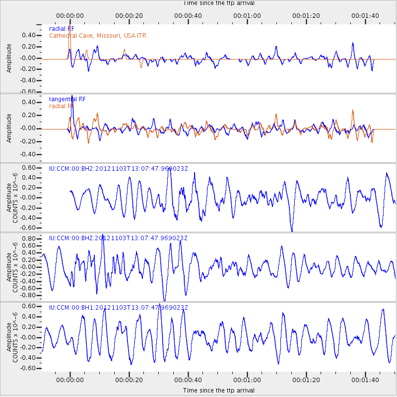
CCM Cathedral Cave, Missouri, USA - Earthquake Result Viewer
*The percent match for this event was below the threshold and hence no stack was calculated.
| Earthquake location: |
Central Mid-Atlantic Ridge |
| Earthquake latitude/longitude: |
7.0/-34.1 |
| Earthquake time(UTC): |
2012/11/03 (308) 12:58:12 GMT |
| Earthquake Depth: |
10 km |
| Earthquake Magnitude: |
5.5 MB, 5.2 MS, 5.6 MW, 5.6 MW |
| Earthquake Catalog/Contributor: |
WHDF/NEIC |
|
| Network: |
IU Global Seismograph Network (GSN - IRIS/USGS) |
| Station: |
CCM Cathedral Cave, Missouri, USA |
| Lat/Lon: |
38.06 N/91.24 W |
| Elevation: |
222 m |
|
| Distance: |
60.0 deg |
| Az: |
310.026 deg |
| Baz: |
105.678 deg |
| Ray Param: |
$rayparam |
*The percent match for this event was below the threshold and hence was not used in the summary stack. |
|
| Radial Match: |
57.562695 % |
| Radial Bump: |
400 |
| Transverse Match: |
69.50911 % |
| Transverse Bump: |
400 |
| SOD ConfigId: |
558545 |
| Insert Time: |
2013-09-17 22:19:20.465 +0000 |
| GWidth: |
2.5 |
| Max Bumps: |
400 |
| Tol: |
0.001 |
|
Signal To Noise
| Channel | StoN | STA | LTA |
| IU:CCM:00:BHZ:20121103T13:07:47.969023Z | 0.9136335 | 2.801222E-7 | 3.0660237E-7 |
| IU:CCM:00:BH1:20121103T13:07:47.969023Z | 1.1395952 | 2.3119937E-7 | 2.0287851E-7 |
| IU:CCM:00:BH2:20121103T13:07:47.969023Z | 1.4401611 | 2.8507458E-7 | 1.9794632E-7 |
| Arrivals |
| Ps | |
| PpPs | |
| PsPs/PpSs | |


