You are here: Home > Network List > II - Global Seismograph Network (GSN - IRIS/IDA) Stations List
> Station WRAB Tennant Creek, NT, Australia > Earthquake Result Viewer
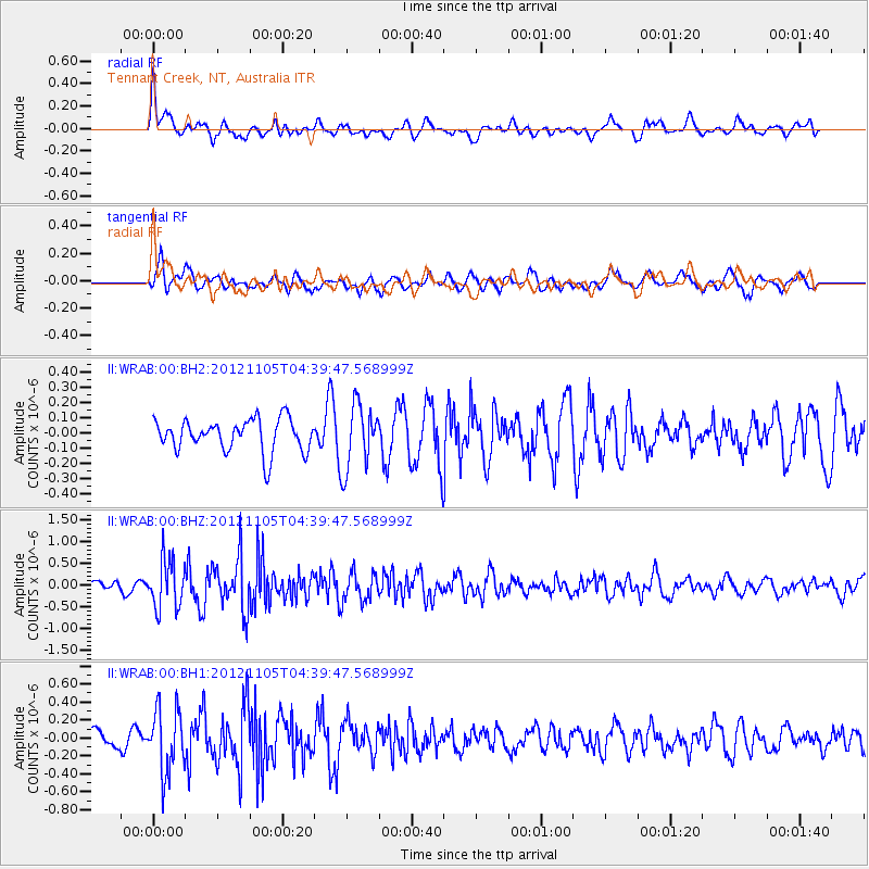
WRAB Tennant Creek, NT, Australia - Earthquake Result Viewer
*The percent match for this event was below the threshold and hence no stack was calculated.
| Earthquake location: |
Off East Coast Of Honshu, Japan |
| Earthquake latitude/longitude: |
37.8/143.6 |
| Earthquake time(UTC): |
2012/11/05 (310) 04:30:26 GMT |
| Earthquake Depth: |
19 km |
| Earthquake Magnitude: |
5.7 MB, 5.2 MS, 5.6 MW, 5.6 MW |
| Earthquake Catalog/Contributor: |
WHDF/NEIC |
|
| Network: |
II Global Seismograph Network (GSN - IRIS/IDA) |
| Station: |
WRAB Tennant Creek, NT, Australia |
| Lat/Lon: |
19.93 S/134.36 E |
| Elevation: |
366 m |
|
| Distance: |
58.1 deg |
| Az: |
190.264 deg |
| Baz: |
8.63 deg |
| Ray Param: |
$rayparam |
*The percent match for this event was below the threshold and hence was not used in the summary stack. |
|
| Radial Match: |
64.36957 % |
| Radial Bump: |
400 |
| Transverse Match: |
73.80466 % |
| Transverse Bump: |
400 |
| SOD ConfigId: |
558545 |
| Insert Time: |
2013-09-17 22:23:53.214 +0000 |
| GWidth: |
2.5 |
| Max Bumps: |
400 |
| Tol: |
0.001 |
|
Signal To Noise
| Channel | StoN | STA | LTA |
| II:WRAB:00:BHZ:20121105T04:39:47.568999Z | 5.063545 | 5.5756595E-7 | 1.10113746E-7 |
| II:WRAB:00:BH1:20121105T04:39:47.568999Z | 3.876712 | 3.5687899E-7 | 9.205713E-8 |
| II:WRAB:00:BH2:20121105T04:39:47.568999Z | 2.0282438 | 2.1230136E-7 | 1.046725E-7 |
| Arrivals |
| Ps | |
| PpPs | |
| PsPs/PpSs | |


