You are here: Home > Network List > II - Global Seismograph Network (GSN - IRIS/IDA) Stations List
> Station ABPO Ambohimpanompo, Madagascar > Earthquake Result Viewer
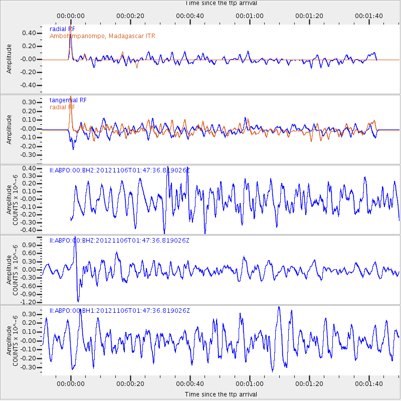
ABPO Ambohimpanompo, Madagascar - Earthquake Result Viewer
*The percent match for this event was below the threshold and hence no stack was calculated.
| Earthquake location: |
Minahassa Peninsula, Sulawesi |
| Earthquake latitude/longitude: |
1.4/122.2 |
| Earthquake time(UTC): |
2012/11/06 (311) 01:36:21 GMT |
| Earthquake Depth: |
25 km |
| Earthquake Magnitude: |
5.7 MB, 5.2 MS, 5.7 MW, 5.6 MW |
| Earthquake Catalog/Contributor: |
WHDF/NEIC |
|
| Network: |
II Global Seismograph Network (GSN - IRIS/IDA) |
| Station: |
ABPO Ambohimpanompo, Madagascar |
| Lat/Lon: |
19.02 S/47.23 E |
| Elevation: |
1528 m |
|
| Distance: |
76.3 deg |
| Az: |
250.161 deg |
| Baz: |
83.705 deg |
| Ray Param: |
$rayparam |
*The percent match for this event was below the threshold and hence was not used in the summary stack. |
|
| Radial Match: |
51.06799 % |
| Radial Bump: |
400 |
| Transverse Match: |
63.40149 % |
| Transverse Bump: |
400 |
| SOD ConfigId: |
558545 |
| Insert Time: |
2013-09-17 22:27:52.455 +0000 |
| GWidth: |
2.5 |
| Max Bumps: |
400 |
| Tol: |
0.001 |
|
Signal To Noise
| Channel | StoN | STA | LTA |
| II:ABPO:00:BHZ:20121106T01:47:36.819026Z | 4.467256 | 5.908995E-7 | 1.3227348E-7 |
| II:ABPO:00:BH1:20121106T01:47:36.819026Z | 2.1832607 | 2.056501E-7 | 9.4194014E-8 |
| II:ABPO:00:BH2:20121106T01:47:36.819026Z | 1.392387 | 2.1306539E-7 | 1.5302167E-7 |
| Arrivals |
| Ps | |
| PpPs | |
| PsPs/PpSs | |


