You are here: Home > Network List > IU - Global Seismograph Network (GSN - IRIS/USGS) Stations List
> Station CTAO Charters Towers, Australia > Earthquake Result Viewer
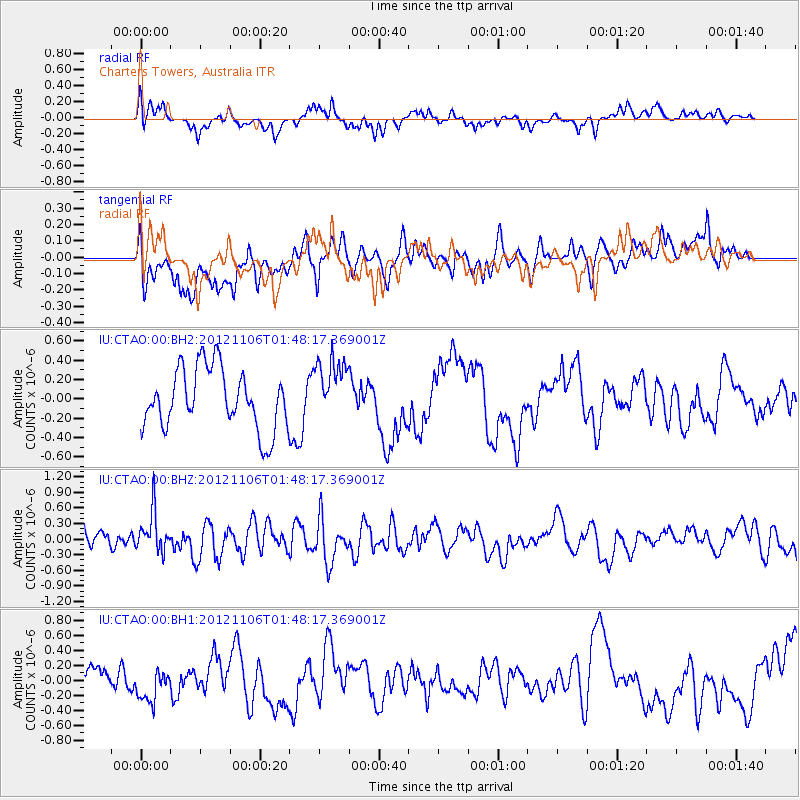
CTAO Charters Towers, Australia - Earthquake Result Viewer
*The percent match for this event was below the threshold and hence no stack was calculated.
| Earthquake location: |
Minahassa Peninsula, Sulawesi |
| Earthquake latitude/longitude: |
1.4/122.2 |
| Earthquake time(UTC): |
2012/11/06 (311) 01:42:26 GMT |
| Earthquake Depth: |
35 km |
| Earthquake Magnitude: |
5.6 MW, 5.4 MB, 5.6 MW |
| Earthquake Catalog/Contributor: |
WHDF/NEIC |
|
| Network: |
IU Global Seismograph Network (GSN - IRIS/USGS) |
| Station: |
CTAO Charters Towers, Australia |
| Lat/Lon: |
20.09 S/146.25 E |
| Elevation: |
357 m |
|
| Distance: |
31.8 deg |
| Az: |
133.303 deg |
| Baz: |
309.281 deg |
| Ray Param: |
$rayparam |
*The percent match for this event was below the threshold and hence was not used in the summary stack. |
|
| Radial Match: |
43.413147 % |
| Radial Bump: |
400 |
| Transverse Match: |
52.539936 % |
| Transverse Bump: |
400 |
| SOD ConfigId: |
558545 |
| Insert Time: |
2013-09-17 22:30:55.555 +0000 |
| GWidth: |
2.5 |
| Max Bumps: |
400 |
| Tol: |
0.001 |
|
Signal To Noise
| Channel | StoN | STA | LTA |
| IU:CTAO:00:BHZ:20121106T01:48:17.369001Z | 1.832503 | 3.815161E-7 | 2.0819397E-7 |
| IU:CTAO:00:BH1:20121106T01:48:17.369001Z | 1.0114814 | 2.1325653E-7 | 2.1083585E-7 |
| IU:CTAO:00:BH2:20121106T01:48:17.369001Z | 1.0274893 | 3.2128554E-7 | 3.126899E-7 |
| Arrivals |
| Ps | |
| PpPs | |
| PsPs/PpSs | |


