You are here: Home > Network List > II - Global Seismograph Network (GSN - IRIS/IDA) Stations List
> Station ABPO Ambohimpanompo, Madagascar > Earthquake Result Viewer
ABPO Ambohimpanompo, Madagascar - Earthquake Result Viewer
| Earthquake location: |
Carlsberg Ridge |
| Earthquake latitude/longitude: |
10.0/57.2 |
| Earthquake time(UTC): |
2012/11/06 (311) 06:17:27 GMT |
| Earthquake Depth: |
10 km |
| Earthquake Magnitude: |
5.7 MB, 5.3 MS, 5.6 MW, 5.6 MW |
| Earthquake Catalog/Contributor: |
WHDF/NEIC |
|
| Network: |
II Global Seismograph Network (GSN - IRIS/IDA) |
| Station: |
ABPO Ambohimpanompo, Madagascar |
| Lat/Lon: |
19.02 S/47.23 E |
| Elevation: |
1528 m |
|
| Distance: |
30.4 deg |
| Az: |
198.876 deg |
| Baz: |
19.686 deg |
| Ray Param: |
0.079334 |
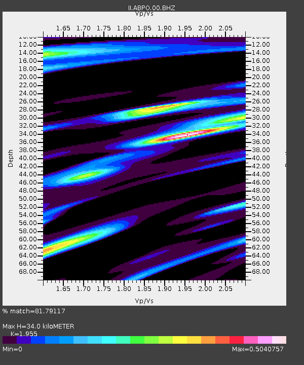
| Estimated Moho Depth: |
34.0 km |
| Estimated Crust Vp/Vs: |
1.96 |
| Assumed Crust Vp: |
6.642 km/s |
| Estimated Crust Vs: |
3.397 km/s |
| Estimated Crust Poisson's Ratio: |
0.32 |
|
| Radial Match: |
81.79117 % |
| Radial Bump: |
304 |
| Transverse Match: |
60.843052 % |
| Transverse Bump: |
400 |
| SOD ConfigId: |
558545 |
| Insert Time: |
2013-09-17 22:32:01.475 +0000 |
| GWidth: |
2.5 |
| Max Bumps: |
400 |
| Tol: |
0.001 |
|

Signal To Noise
| Channel | StoN | STA | LTA |
| II:ABPO:00:BHZ:20121106T06:23:09.618989Z | 6.371702 | 8.8586717E-7 | 1.3903147E-7 |
| II:ABPO:00:BH1:20121106T06:23:09.618989Z | 3.562018 | 4.9963467E-7 | 1.402673E-7 |
| II:ABPO:00:BH2:20121106T06:23:09.618989Z | 1.9268208 | 1.9219767E-7 | 9.9748604E-8 |
| Arrivals |
| Ps | 5.3 SECOND |
| PpPs | 14 SECOND |
| PsPs/PpSs | 19 SECOND |


