You are here: Home > Network List > UW - Pacific Northwest Regional Seismic Network Stations List
> Station YACT Amboy, WA, USA > Earthquake Result Viewer
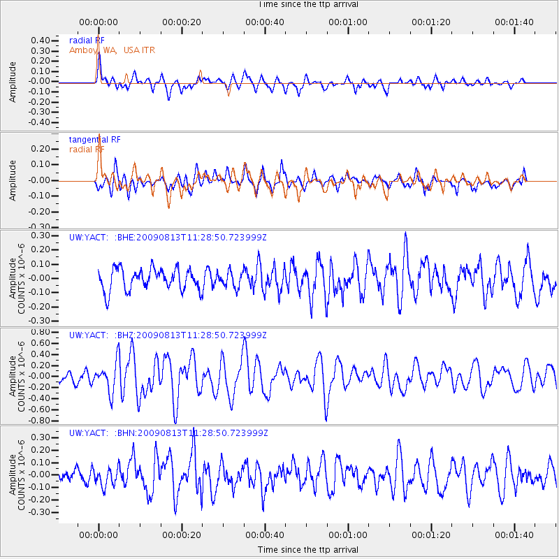
YACT Amboy, WA, USA - Earthquake Result Viewer
*The percent match for this event was below the threshold and hence no stack was calculated.
| Earthquake location: |
Tonga Islands |
| Earthquake latitude/longitude: |
-21.7/-174.6 |
| Earthquake time(UTC): |
2009/08/13 (225) 11:17:01 GMT |
| Earthquake Depth: |
10 km |
| Earthquake Magnitude: |
5.6 MW, 5.3 MB |
| Earthquake Catalog/Contributor: |
WHDF/NEIC |
|
| Network: |
UW Pacific Northwest Regional Seismic Network |
| Station: |
YACT Amboy, WA, USA |
| Lat/Lon: |
45.93 N/122.42 W |
| Elevation: |
211 m |
|
| Distance: |
82.2 deg |
| Az: |
33.793 deg |
| Baz: |
227.844 deg |
| Ray Param: |
$rayparam |
*The percent match for this event was below the threshold and hence was not used in the summary stack. |
|
| Radial Match: |
75.73811 % |
| Radial Bump: |
400 |
| Transverse Match: |
67.12682 % |
| Transverse Bump: |
400 |
| SOD ConfigId: |
2622 |
| Insert Time: |
2010-02-27 05:23:33.566 +0000 |
| GWidth: |
2.5 |
| Max Bumps: |
400 |
| Tol: |
0.001 |
|
Signal To Noise
| Channel | StoN | STA | LTA |
| UW:YACT: :BHZ:20090813T11:28:50.723999Z | 4.023035 | 2.7618046E-7 | 6.8649776E-8 |
| UW:YACT: :BHN:20090813T11:28:50.723999Z | 1.6511986 | 7.2911256E-8 | 4.4156565E-8 |
| UW:YACT: :BHE:20090813T11:28:50.723999Z | 0.7291472 | 5.4714388E-8 | 7.5038876E-8 |
| Arrivals |
| Ps | |
| PpPs | |
| PsPs/PpSs | |


