You are here: Home > Network List > IU - Global Seismograph Network (GSN - IRIS/USGS) Stations List
> Station POHA Pohakuloa, Hawaii, USA > Earthquake Result Viewer
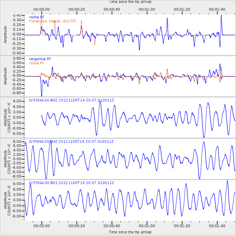
POHA Pohakuloa, Hawaii, USA - Earthquake Result Viewer
*The percent match for this event was below the threshold and hence no stack was calculated.
| Earthquake location: |
Bismarck Sea |
| Earthquake latitude/longitude: |
-3.8/148.8 |
| Earthquake time(UTC): |
2012/11/06 (311) 14:20:36 GMT |
| Earthquake Depth: |
10 km |
| Earthquake Magnitude: |
5.5 MW |
| Earthquake Catalog/Contributor: |
NEIC PDE/NEIC PDE-W |
|
| Network: |
IU Global Seismograph Network (GSN - IRIS/USGS) |
| Station: |
POHA Pohakuloa, Hawaii, USA |
| Lat/Lon: |
19.76 N/155.53 W |
| Elevation: |
1990 m |
|
| Distance: |
59.4 deg |
| Az: |
64.508 deg |
| Baz: |
252.991 deg |
| Ray Param: |
$rayparam |
*The percent match for this event was below the threshold and hence was not used in the summary stack. |
|
| Radial Match: |
58.985332 % |
| Radial Bump: |
400 |
| Transverse Match: |
53.060932 % |
| Transverse Bump: |
400 |
| SOD ConfigId: |
558545 |
| Insert Time: |
2013-09-17 22:38:56.119 +0000 |
| GWidth: |
2.5 |
| Max Bumps: |
400 |
| Tol: |
0.001 |
|
Signal To Noise
| Channel | StoN | STA | LTA |
| IU:POHA:00:BHZ:20121106T14:30:07.919011Z | 1.569561 | 5.382362E-6 | 3.429215E-6 |
| IU:POHA:00:BH1:20121106T14:30:07.919011Z | 0.5070711 | 1.8000317E-6 | 3.5498606E-6 |
| IU:POHA:00:BH2:20121106T14:30:07.919011Z | 3.2238936 | 5.8955366E-6 | 1.8287008E-6 |
| Arrivals |
| Ps | |
| PpPs | |
| PsPs/PpSs | |


