You are here: Home > Network List > II - Global Seismograph Network (GSN - IRIS/IDA) Stations List
> Station CMLA Cha de Macela, Sao Miguel Island, Azores > Earthquake Result Viewer
CMLA Cha de Macela, Sao Miguel Island, Azores - Earthquake Result Viewer

| Earthquake location: |
Near Coast Of Guatemala |
| Earthquake latitude/longitude: |
14.0/-91.9 |
| Earthquake time(UTC): |
2012/11/07 (312) 16:35:46 GMT |
| Earthquake Depth: |
24 km |
| Earthquake Magnitude: |
7.3 MW, 6.6 MB, 7.4 MS, 7.4 MW |
| Earthquake Catalog/Contributor: |
NEIC PDE/NEIC PDE-W |
|
| Network: |
II Global Seismograph Network (GSN - IRIS/IDA) |
| Station: |
CMLA Cha de Macela, Sao Miguel Island, Azores |
| Lat/Lon: |
37.76 N/25.52 W |
| Elevation: |
429 m |
|
| Distance: |
62.9 deg |
| Az: |
54.617 deg |
| Baz: |
266.98 deg |
| Ray Param: |
0.05986436 |
| Estimated Moho Depth: |
30.25 km |
| Estimated Crust Vp/Vs: |
1.91 |
| Assumed Crust Vp: |
4.802 km/s |
| Estimated Crust Vs: |
2.517 km/s |
| Estimated Crust Poisson's Ratio: |
0.31 |
|
| Radial Match: |
86.25551 % |
| Radial Bump: |
400 |
| Transverse Match: |
72.39017 % |
| Transverse Bump: |
400 |
| SOD ConfigId: |
558545 |
| Insert Time: |
2013-09-17 22:44:19.022 +0000 |
| GWidth: |
2.5 |
| Max Bumps: |
400 |
| Tol: |
0.001 |
|
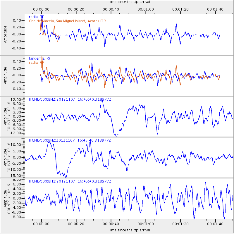
Signal To Noise
| Channel | StoN | STA | LTA |
| II:CMLA:00:BHZ:20121107T16:45:40.318977Z | 5.097881 | 6.5654795E-6 | 1.2878841E-6 |
| II:CMLA:00:BH1:20121107T16:45:40.318977Z | 0.49463657 | 1.0973015E-6 | 2.2183995E-6 |
| II:CMLA:00:BH2:20121107T16:45:40.318977Z | 3.2456982 | 4.6529444E-6 | 1.4335727E-6 |
| Arrivals |
| Ps | 5.8 SECOND |
| PpPs | 18 SECOND |
| PsPs/PpSs | 24 SECOND |


