You are here: Home > Network List > IU - Global Seismograph Network (GSN - IRIS/USGS) Stations List
> Station COLA College Outpost, Alaska, USA > Earthquake Result Viewer
COLA College Outpost, Alaska, USA - Earthquake Result Viewer
| Earthquake location: |
Near Coast Of Guatemala |
| Earthquake latitude/longitude: |
14.0/-91.9 |
| Earthquake time(UTC): |
2012/11/07 (312) 16:35:46 GMT |
| Earthquake Depth: |
24 km |
| Earthquake Magnitude: |
7.3 MW, 6.6 MB, 7.4 MS, 7.4 MW |
| Earthquake Catalog/Contributor: |
NEIC PDE/NEIC PDE-W |
|
| Network: |
IU Global Seismograph Network (GSN - IRIS/USGS) |
| Station: |
COLA College Outpost, Alaska, USA |
| Lat/Lon: |
64.87 N/147.86 W |
| Elevation: |
200 m |
|
| Distance: |
63.3 deg |
| Az: |
336.67 deg |
| Baz: |
115.791 deg |
| Ray Param: |
0.05962846 |
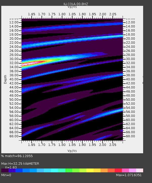
| Estimated Moho Depth: |
32.25 km |
| Estimated Crust Vp/Vs: |
1.63 |
| Assumed Crust Vp: |
6.566 km/s |
| Estimated Crust Vs: |
4.028 km/s |
| Estimated Crust Poisson's Ratio: |
0.20 |
|
| Radial Match: |
96.12855 % |
| Radial Bump: |
400 |
| Transverse Match: |
87.58394 % |
| Transverse Bump: |
400 |
| SOD ConfigId: |
558545 |
| Insert Time: |
2013-09-17 22:44:47.991 +0000 |
| GWidth: |
2.5 |
| Max Bumps: |
400 |
| Tol: |
0.001 |
|

Signal To Noise
| Channel | StoN | STA | LTA |
| IU:COLA:00:BHZ:20121107T16:45:42.768989Z | 66.219154 | 1.320475E-5 | 1.9940983E-7 |
| IU:COLA:00:BH1:20121107T16:45:42.768989Z | 16.821234 | 2.251069E-6 | 1.3382305E-7 |
| IU:COLA:00:BH2:20121107T16:45:42.768989Z | 36.3746 | 6.144764E-6 | 1.6893009E-7 |
| Arrivals |
| Ps | 3.3 SECOND |
| PpPs | 12 SECOND |
| PsPs/PpSs | 16 SECOND |


