You are here: Home > Network List > IU - Global Seismograph Network (GSN - IRIS/USGS) Stations List
> Station JOHN Johnston Island, USA > Earthquake Result Viewer
JOHN Johnston Island, USA - Earthquake Result Viewer

| Earthquake location: |
Near Coast Of Guatemala |
| Earthquake latitude/longitude: |
14.0/-91.9 |
| Earthquake time(UTC): |
2012/11/07 (312) 16:35:46 GMT |
| Earthquake Depth: |
24 km |
| Earthquake Magnitude: |
7.3 MW, 6.6 MB, 7.4 MS, 7.4 MW |
| Earthquake Catalog/Contributor: |
NEIC PDE/NEIC PDE-W |
|
| Network: |
IU Global Seismograph Network (GSN - IRIS/USGS) |
| Station: |
JOHN Johnston Island, USA |
| Lat/Lon: |
16.73 N/169.53 W |
| Elevation: |
2.0 m |
|
| Distance: |
74.5 deg |
| Az: |
283.718 deg |
| Baz: |
79.797 deg |
| Ray Param: |
0.05229093 |
| Estimated Moho Depth: |
14.5 km |
| Estimated Crust Vp/Vs: |
2.04 |
| Assumed Crust Vp: |
4.24 km/s |
| Estimated Crust Vs: |
2.081 km/s |
| Estimated Crust Poisson's Ratio: |
0.34 |
|
| Radial Match: |
80.985756 % |
| Radial Bump: |
400 |
| Transverse Match: |
59.370693 % |
| Transverse Bump: |
400 |
| SOD ConfigId: |
558545 |
| Insert Time: |
2013-09-17 22:44:58.133 +0000 |
| GWidth: |
2.5 |
| Max Bumps: |
400 |
| Tol: |
0.001 |
|
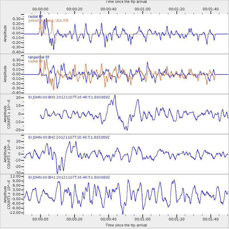
Signal To Noise
| Channel | StoN | STA | LTA |
| IU:JOHN:00:BHZ:20121107T16:46:51.893989Z | 3.5041575 | 8.722072E-6 | 2.489064E-6 |
| IU:JOHN:00:BH1:20121107T16:46:51.893989Z | 1.5386283 | 2.4298513E-6 | 1.579232E-6 |
| IU:JOHN:00:BH2:20121107T16:46:51.893989Z | 0.94574124 | 2.9168095E-6 | 3.0841518E-6 |
| Arrivals |
| Ps | 3.6 SECOND |
| PpPs | 10 SECOND |
| PsPs/PpSs | 14 SECOND |


