You are here: Home > Network List > IU - Global Seismograph Network (GSN - IRIS/USGS) Stations List
> Station RSSD Black Hills, South Dakota, USA > Earthquake Result Viewer
RSSD Black Hills, South Dakota, USA - Earthquake Result Viewer
| Earthquake location: |
Near Coast Of Guatemala |
| Earthquake latitude/longitude: |
14.0/-91.9 |
| Earthquake time(UTC): |
2012/11/07 (312) 16:35:46 GMT |
| Earthquake Depth: |
24 km |
| Earthquake Magnitude: |
7.3 MW, 6.6 MB, 7.4 MS, 7.4 MW |
| Earthquake Catalog/Contributor: |
NEIC PDE/NEIC PDE-W |
|
| Network: |
IU Global Seismograph Network (GSN - IRIS/USGS) |
| Station: |
RSSD Black Hills, South Dakota, USA |
| Lat/Lon: |
44.12 N/104.04 W |
| Elevation: |
2090 m |
|
| Distance: |
31.8 deg |
| Az: |
343.283 deg |
| Baz: |
157.189 deg |
| Ray Param: |
0.0789045 |
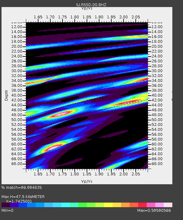
| Estimated Moho Depth: |
47.5 km |
| Estimated Crust Vp/Vs: |
1.74 |
| Assumed Crust Vp: |
6.242 km/s |
| Estimated Crust Vs: |
3.582 km/s |
| Estimated Crust Poisson's Ratio: |
0.25 |
|
| Radial Match: |
96.994835 % |
| Radial Bump: |
391 |
| Transverse Match: |
80.94919 % |
| Transverse Bump: |
400 |
| SOD ConfigId: |
558545 |
| Insert Time: |
2013-09-17 22:45:48.066 +0000 |
| GWidth: |
2.5 |
| Max Bumps: |
400 |
| Tol: |
0.001 |
|
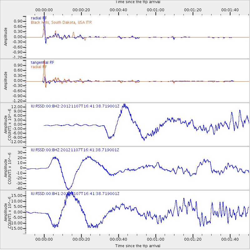
Signal To Noise
| Channel | StoN | STA | LTA |
| IU:RSSD:00:BHZ:20121107T16:41:38.719001Z | 24.703375 | 8.663252E-6 | 3.5069104E-7 |
| IU:RSSD:00:BH1:20121107T16:41:38.719001Z | 11.556129 | 5.1256256E-6 | 4.4354175E-7 |
| IU:RSSD:00:BH2:20121107T16:41:38.719001Z | 11.190553 | 3.4576653E-6 | 3.0898076E-7 |
| Arrivals |
| Ps | 6.1 SECOND |
| PpPs | 19 SECOND |
| PsPs/PpSs | 25 SECOND |


