You are here: Home > Network List > US - United States National Seismic Network Stations List
> Station EGAK Eagle, Central Alaska, Alaska, USA > Earthquake Result Viewer
EGAK Eagle, Central Alaska, Alaska, USA - Earthquake Result Viewer
| Earthquake location: |
Near Coast Of Guatemala |
| Earthquake latitude/longitude: |
14.0/-91.9 |
| Earthquake time(UTC): |
2012/11/07 (312) 16:35:46 GMT |
| Earthquake Depth: |
24 km |
| Earthquake Magnitude: |
7.3 MW, 6.6 MB, 7.4 MS, 7.4 MW |
| Earthquake Catalog/Contributor: |
NEIC PDE/NEIC PDE-W |
|
| Network: |
US United States National Seismic Network |
| Station: |
EGAK Eagle, Central Alaska, Alaska, USA |
| Lat/Lon: |
64.78 N/141.16 W |
| Elevation: |
297 m |
|
| Distance: |
60.8 deg |
| Az: |
338.156 deg |
| Baz: |
122.549 deg |
| Ray Param: |
0.061286163 |
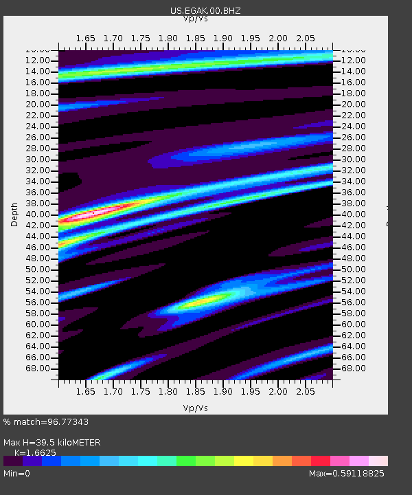
| Estimated Moho Depth: |
39.5 km |
| Estimated Crust Vp/Vs: |
1.66 |
| Assumed Crust Vp: |
6.566 km/s |
| Estimated Crust Vs: |
3.95 km/s |
| Estimated Crust Poisson's Ratio: |
0.22 |
|
| Radial Match: |
96.77343 % |
| Radial Bump: |
400 |
| Transverse Match: |
76.58573 % |
| Transverse Bump: |
400 |
| SOD ConfigId: |
558545 |
| Insert Time: |
2013-09-17 22:46:33.477 +0000 |
| GWidth: |
2.5 |
| Max Bumps: |
400 |
| Tol: |
0.001 |
|

Signal To Noise
| Channel | StoN | STA | LTA |
| US:EGAK:00:BHZ:20121107T16:45:25.648994Z | 84.287834 | 1.021882E-5 | 1.2123718E-7 |
| US:EGAK:00:BH1:20121107T16:45:25.648994Z | 17.005634 | 2.3123805E-6 | 1.359773E-7 |
| US:EGAK:00:BH2:20121107T16:45:25.648994Z | 19.954319 | 4.453436E-6 | 2.2318156E-7 |
| Arrivals |
| Ps | 4.2 SECOND |
| PpPs | 15 SECOND |
| PsPs/PpSs | 19 SECOND |


