You are here: Home > Network List > US - United States National Seismic Network Stations List
> Station EGMT Eagleton, Montana, USA > Earthquake Result Viewer
EGMT Eagleton, Montana, USA - Earthquake Result Viewer

| Earthquake location: |
Near Coast Of Guatemala |
| Earthquake latitude/longitude: |
14.0/-91.9 |
| Earthquake time(UTC): |
2012/11/07 (312) 16:35:46 GMT |
| Earthquake Depth: |
24 km |
| Earthquake Magnitude: |
7.3 MW, 6.6 MB, 7.4 MS, 7.4 MW |
| Earthquake Catalog/Contributor: |
NEIC PDE/NEIC PDE-W |
|
| Network: |
US United States National Seismic Network |
| Station: |
EGMT Eagleton, Montana, USA |
| Lat/Lon: |
48.02 N/109.75 W |
| Elevation: |
1055 m |
|
| Distance: |
37.0 deg |
| Az: |
340.012 deg |
| Baz: |
150.377 deg |
| Ray Param: |
0.07632008 |
| Estimated Moho Depth: |
47.0 km |
| Estimated Crust Vp/Vs: |
1.65 |
| Assumed Crust Vp: |
6.438 km/s |
| Estimated Crust Vs: |
3.902 km/s |
| Estimated Crust Poisson's Ratio: |
0.21 |
|
| Radial Match: |
94.04384 % |
| Radial Bump: |
327 |
| Transverse Match: |
63.029953 % |
| Transverse Bump: |
400 |
| SOD ConfigId: |
558545 |
| Insert Time: |
2013-09-17 22:46:33.912 +0000 |
| GWidth: |
2.5 |
| Max Bumps: |
400 |
| Tol: |
0.001 |
|
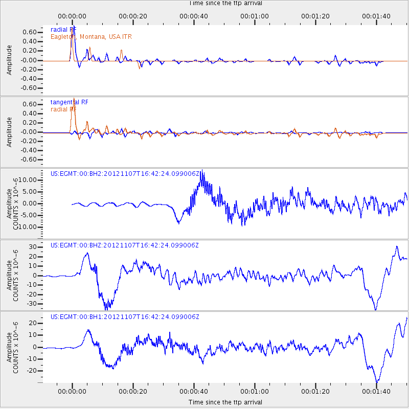
Signal To Noise
| Channel | StoN | STA | LTA |
| US:EGMT:00:BHZ:20121107T16:42:24.099006Z | 31.334772 | 1.1062312E-5 | 3.530363E-7 |
| US:EGMT:00:BH1:20121107T16:42:24.099006Z | 10.190426 | 5.097971E-6 | 5.002707E-7 |
| US:EGMT:00:BH2:20121107T16:42:24.099006Z | 4.895703 | 2.900249E-6 | 5.924071E-7 |
| Arrivals |
| Ps | 5.1 SECOND |
| PpPs | 18 SECOND |
| PsPs/PpSs | 23 SECOND |


