You are here: Home > Network List > US - United States National Seismic Network Stations List
> Station LKWY Lake (Yellowstone--Lake), Wyoming, USA > Earthquake Result Viewer
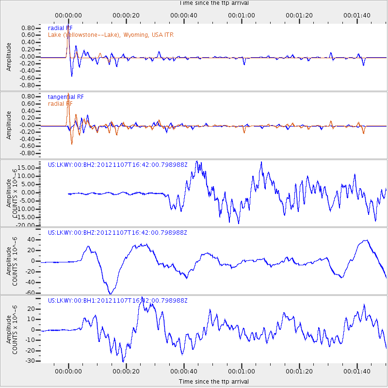
LKWY Lake (Yellowstone--Lake), Wyoming, USA - Earthquake Result Viewer

| Earthquake location: |
Near Coast Of Guatemala |
| Earthquake latitude/longitude: |
14.0/-91.9 |
| Earthquake time(UTC): |
2012/11/07 (312) 16:35:46 GMT |
| Earthquake Depth: |
24 km |
| Earthquake Magnitude: |
7.3 MW, 6.6 MB, 7.4 MS, 7.4 MW |
| Earthquake Catalog/Contributor: |
NEIC PDE/NEIC PDE-W |
|
| Network: |
US United States National Seismic Network |
| Station: |
LKWY Lake (Yellowstone--Lake), Wyoming, USA |
| Lat/Lon: |
44.57 N/110.40 W |
| Elevation: |
2424 m |
|
| Distance: |
34.3 deg |
| Az: |
336.268 deg |
| Baz: |
146.869 deg |
| Ray Param: |
0.07777199 |
| Estimated Moho Depth: |
16.75 km |
| Estimated Crust Vp/Vs: |
2.00 |
| Assumed Crust Vp: |
6.35 km/s |
| Estimated Crust Vs: |
3.183 km/s |
| Estimated Crust Poisson's Ratio: |
0.33 |
|
| Radial Match: |
80.05663 % |
| Radial Bump: |
400 |
| Transverse Match: |
75.395195 % |
| Transverse Bump: |
400 |
| SOD ConfigId: |
558545 |
| Insert Time: |
2013-09-17 22:46:56.186 +0000 |
| GWidth: |
2.5 |
| Max Bumps: |
400 |
| Tol: |
0.001 |
|
Signal To Noise
| Channel | StoN | STA | LTA |
| US:LKWY:00:BHZ:20121107T16:42:00.798988Z | 10.617829 | 3.101531E-6 | 2.9210594E-7 |
| US:LKWY:00:BH1:20121107T16:42:00.798988Z | 3.903867 | 1.7873019E-6 | 4.5782858E-7 |
| US:LKWY:00:BH2:20121107T16:42:00.798988Z | 1.9044293 | 7.7349887E-7 | 4.0615782E-7 |
| Arrivals |
| Ps | 2.8 SECOND |
| PpPs | 7.4 SECOND |
| PsPs/PpSs | 10 SECOND |


