You are here: Home > Network List > US - United States National Seismic Network Stations List
> Station LONY Lake Ozonia, New York, USA > Earthquake Result Viewer
LONY Lake Ozonia, New York, USA - Earthquake Result Viewer
| Earthquake location: |
Near Coast Of Guatemala |
| Earthquake latitude/longitude: |
14.0/-91.9 |
| Earthquake time(UTC): |
2012/11/07 (312) 16:35:46 GMT |
| Earthquake Depth: |
24 km |
| Earthquake Magnitude: |
7.3 MW, 6.6 MB, 7.4 MS, 7.4 MW |
| Earthquake Catalog/Contributor: |
NEIC PDE/NEIC PDE-W |
|
| Network: |
US United States National Seismic Network |
| Station: |
LONY Lake Ozonia, New York, USA |
| Lat/Lon: |
44.62 N/74.58 W |
| Elevation: |
440 m |
|
| Distance: |
33.9 deg |
| Az: |
22.394 deg |
| Baz: |
211.188 deg |
| Ray Param: |
0.077961646 |
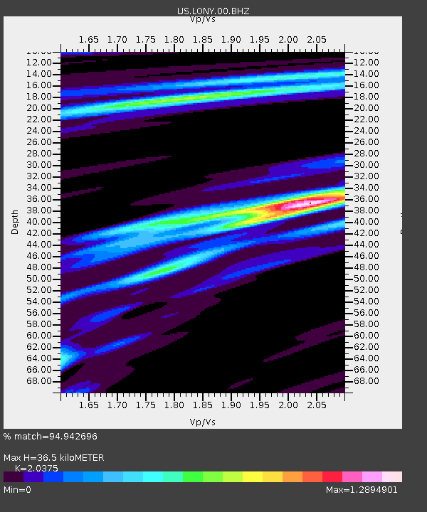
| Estimated Moho Depth: |
36.5 km |
| Estimated Crust Vp/Vs: |
2.04 |
| Assumed Crust Vp: |
6.419 km/s |
| Estimated Crust Vs: |
3.151 km/s |
| Estimated Crust Poisson's Ratio: |
0.34 |
|
| Radial Match: |
94.942696 % |
| Radial Bump: |
315 |
| Transverse Match: |
85.98413 % |
| Transverse Bump: |
353 |
| SOD ConfigId: |
558545 |
| Insert Time: |
2013-09-17 22:46:56.245 +0000 |
| GWidth: |
2.5 |
| Max Bumps: |
400 |
| Tol: |
0.001 |
|
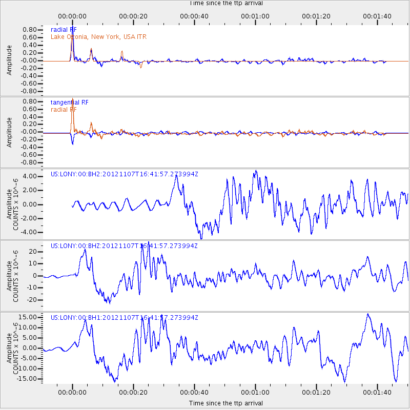
Signal To Noise
| Channel | StoN | STA | LTA |
| US:LONY:00:BHZ:20121107T16:41:57.273994Z | 15.244325 | 1.1785756E-5 | 7.7312416E-7 |
| US:LONY:00:BH1:20121107T16:41:57.273994Z | 9.345423 | 7.3399165E-6 | 7.854023E-7 |
| US:LONY:00:BH2:20121107T16:41:57.273994Z | 4.4850993 | 2.0285293E-6 | 4.522819E-7 |
| Arrivals |
| Ps | 6.3 SECOND |
| PpPs | 16 SECOND |
| PsPs/PpSs | 22 SECOND |


