You are here: Home > Network List > US - United States National Seismic Network Stations List
> Station WRAK Wrangell Island, Southeastern Alaska, Alaska, USA > Earthquake Result Viewer
WRAK Wrangell Island, Southeastern Alaska, Alaska, USA - Earthquake Result Viewer
| Earthquake location: |
Near Coast Of Guatemala |
| Earthquake latitude/longitude: |
14.0/-91.9 |
| Earthquake time(UTC): |
2012/11/07 (312) 16:35:46 GMT |
| Earthquake Depth: |
24 km |
| Earthquake Magnitude: |
7.3 MW, 6.6 MB, 7.4 MS, 7.4 MW |
| Earthquake Catalog/Contributor: |
NEIC PDE/NEIC PDE-W |
|
| Network: |
US United States National Seismic Network |
| Station: |
WRAK Wrangell Island, Southeastern Alaska, Alaska, USA |
| Lat/Lon: |
56.42 N/132.35 W |
| Elevation: |
81 m |
|
| Distance: |
52.4 deg |
| Az: |
332.931 deg |
| Baz: |
127.35 deg |
| Ray Param: |
0.06674957 |
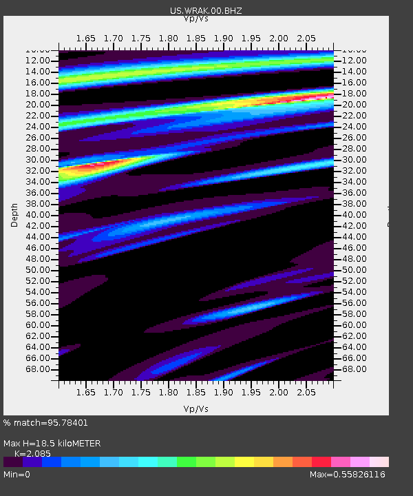
| Estimated Moho Depth: |
18.5 km |
| Estimated Crust Vp/Vs: |
2.09 |
| Assumed Crust Vp: |
6.597 km/s |
| Estimated Crust Vs: |
3.164 km/s |
| Estimated Crust Poisson's Ratio: |
0.35 |
|
| Radial Match: |
95.78401 % |
| Radial Bump: |
361 |
| Transverse Match: |
77.362625 % |
| Transverse Bump: |
400 |
| SOD ConfigId: |
558545 |
| Insert Time: |
2013-09-17 22:47:16.626 +0000 |
| GWidth: |
2.5 |
| Max Bumps: |
400 |
| Tol: |
0.001 |
|
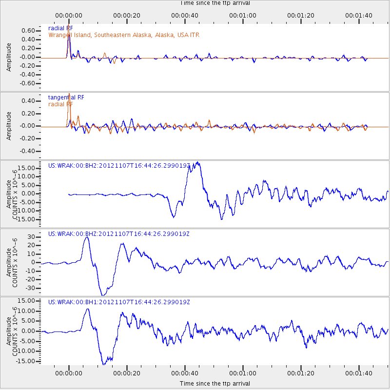
Signal To Noise
| Channel | StoN | STA | LTA |
| US:WRAK:00:BHZ:20121107T16:44:26.299019Z | 11.106977 | 4.635738E-6 | 4.173717E-7 |
| US:WRAK:00:BH1:20121107T16:44:26.299019Z | 5.366461 | 1.4194654E-6 | 2.645068E-7 |
| US:WRAK:00:BH2:20121107T16:44:26.299019Z | 6.6729646 | 1.9429644E-6 | 2.911696E-7 |
| Arrivals |
| Ps | 3.2 SECOND |
| PpPs | 8.2 SECOND |
| PsPs/PpSs | 11 SECOND |


