You are here: Home > Network List > US - United States National Seismic Network Stations List
> Station EGMT Eagleton, Montana, USA > Earthquake Result Viewer
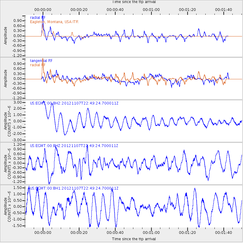
EGMT Eagleton, Montana, USA - Earthquake Result Viewer
*The percent match for this event was below the threshold and hence no stack was calculated.
| Earthquake location: |
Off Coast Of Chiapas, Mexico |
| Earthquake latitude/longitude: |
13.8/-92.2 |
| Earthquake time(UTC): |
2012/11/07 (312) 22:42:48 GMT |
| Earthquake Depth: |
35 km |
| Earthquake Magnitude: |
5.7 MW, 5.5 MD |
| Earthquake Catalog/Contributor: |
NEIC PDE/NEIC PDE-W |
|
| Network: |
US United States National Seismic Network |
| Station: |
EGMT Eagleton, Montana, USA |
| Lat/Lon: |
48.02 N/109.75 W |
| Elevation: |
1055 m |
|
| Distance: |
37.1 deg |
| Az: |
340.327 deg |
| Baz: |
150.85 deg |
| Ray Param: |
$rayparam |
*The percent match for this event was below the threshold and hence was not used in the summary stack. |
|
| Radial Match: |
57.775417 % |
| Radial Bump: |
360 |
| Transverse Match: |
55.816895 % |
| Transverse Bump: |
400 |
| SOD ConfigId: |
558545 |
| Insert Time: |
2013-09-17 22:48:51.745 +0000 |
| GWidth: |
2.5 |
| Max Bumps: |
400 |
| Tol: |
0.001 |
|
Signal To Noise
| Channel | StoN | STA | LTA |
| US:EGMT:00:BHZ:20121107T22:49:24.700011Z | 2.6231897 | 7.1965883E-7 | 2.7434493E-7 |
| US:EGMT:00:BH1:20121107T22:49:24.700011Z | 1.1036185 | 8.5087976E-7 | 7.709908E-7 |
| US:EGMT:00:BH2:20121107T22:49:24.700011Z | 0.5438358 | 7.860898E-7 | 1.4454542E-6 |
| Arrivals |
| Ps | |
| PpPs | |
| PsPs/PpSs | |


