You are here: Home > Network List > UW - Pacific Northwest Regional Seismic Network Stations List
> Station YACT Amboy, WA, USA > Earthquake Result Viewer
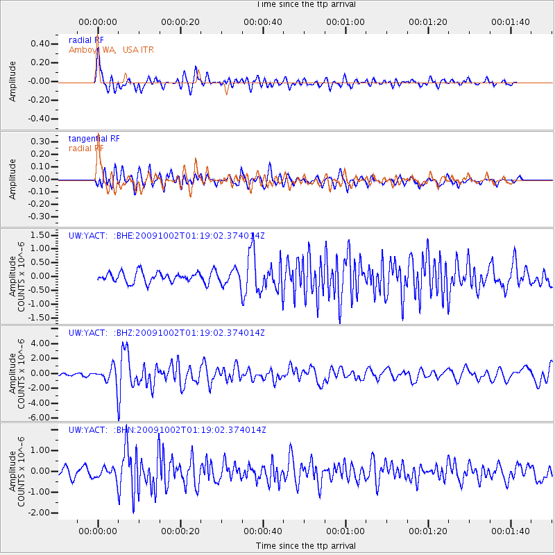
YACT Amboy, WA, USA - Earthquake Result Viewer
*The percent match for this event was below the threshold and hence no stack was calculated.
| Earthquake location: |
Tonga Islands |
| Earthquake latitude/longitude: |
-16.3/-173.5 |
| Earthquake time(UTC): |
2009/10/02 (275) 01:07:39 GMT |
| Earthquake Depth: |
8.0 km |
| Earthquake Magnitude: |
6.1 MB, 6.0 MS, 6.1 MW, 6.1 MW |
| Earthquake Catalog/Contributor: |
WHDF/NEIC |
|
| Network: |
UW Pacific Northwest Regional Seismic Network |
| Station: |
YACT Amboy, WA, USA |
| Lat/Lon: |
45.93 N/122.42 W |
| Elevation: |
211 m |
|
| Distance: |
77.2 deg |
| Az: |
33.817 deg |
| Baz: |
229.965 deg |
| Ray Param: |
$rayparam |
*The percent match for this event was below the threshold and hence was not used in the summary stack. |
|
| Radial Match: |
78.566055 % |
| Radial Bump: |
400 |
| Transverse Match: |
66.243195 % |
| Transverse Bump: |
400 |
| SOD ConfigId: |
2622 |
| Insert Time: |
2010-02-27 05:23:48.342 +0000 |
| GWidth: |
2.5 |
| Max Bumps: |
400 |
| Tol: |
0.001 |
|
Signal To Noise
| Channel | StoN | STA | LTA |
| UW:YACT: :BHZ:20091002T01:19:02.374014Z | 8.578338 | 1.2490757E-6 | 1.4560814E-7 |
| UW:YACT: :BHN:20091002T01:19:02.374014Z | 1.3463894 | 2.6869677E-7 | 1.9956839E-7 |
| UW:YACT: :BHE:20091002T01:19:02.374014Z | 1.6109315 | 2.85092E-7 | 1.7697337E-7 |
| Arrivals |
| Ps | |
| PpPs | |
| PsPs/PpSs | |


