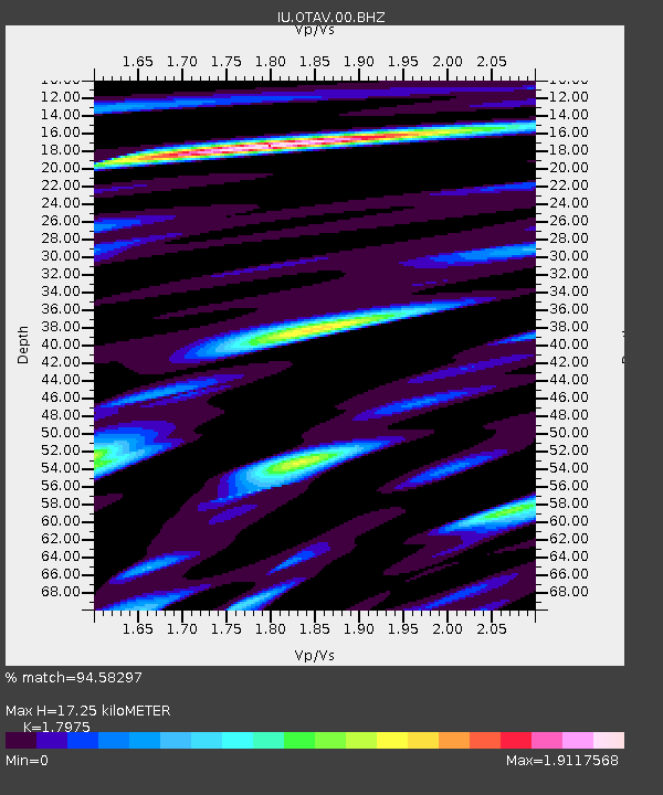
OTAV Otavalo, Ecuador - Earthquake Result Viewer
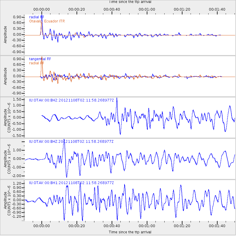
Earthquake location: Vancouver Island, Canada Region
Earthquake latitude/longitude: 49.2/-128.5
Earthquake time(UTC): 2012/11/08 (313) 02:01:50 GMT
Earthquake Depth: 14 km
Earthquake Magnitude: 6.1 MW, 5.9 MB, 6.1 MS, 6.1 MW
Earthquake Catalog/Contributor: NEIC PDE/NEIC PDE-W
Network: IU Global Seismograph Network (GSN - IRIS/USGS)
Station: OTAV Otavalo, Ecuador
Lat/Lon: 0.24 N/78.45 W
Elevation: 3510 m
Distance: 64.9 deg
Az: 122.193 deg
Baz: 326.307 deg
Ray Param: 0.05861898
Estimated Moho Depth: 17.25 km
Estimated Crust Vp/Vs: 1.80
Assumed Crust Vp: 6.472 km/s
Estimated Crust Vs: 3.6 km/s
Estimated Crust Poisson's Ratio: 0.28
Radial Match: 94.58297 %
Radial Bump: 400
Transverse Match: 77.118835 %
Transverse Bump: 400
SOD ConfigId: 558545
Insert Time: 2013-09-17 22:54:27.564 +0000
GWidth: 2.5
Max Bumps: 400
Tol: 0.001

Signal To Noise

ChannelStoNSTALTA
IU:OTAV:00:BHZ:20121108T02:11:58.268977Z5.01976162.8097836E-75.597444E-8
IU:OTAV:00:BH1:20121108T02:11:58.268977Z2.0141561.8243493E-79.0576364E-8
IU:OTAV:00:BH2:20121108T02:11:58.268977Z1.85782812.282292E-71.2284731E-7
Arrivals
Ps2.2 SECOND
PpPs7.1 SECOND
PsPs/PpSs9.4 SECOND