You are here: Home > Network List > US - United States National Seismic Network Stations List
> Station DGMT Dagmar, Montana, USA > Earthquake Result Viewer
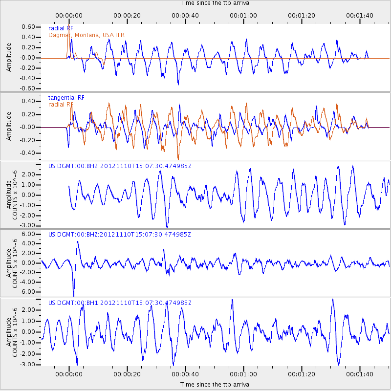
DGMT Dagmar, Montana, USA - Earthquake Result Viewer
*The percent match for this event was below the threshold and hence no stack was calculated.
| Earthquake location: |
Central Peru |
| Earthquake latitude/longitude: |
-8.9/-75.1 |
| Earthquake time(UTC): |
2012/11/10 (315) 14:57:50 GMT |
| Earthquake Depth: |
129 km |
| Earthquake Magnitude: |
6.0 MW, 5.9 MB, 6.0 MW |
| Earthquake Catalog/Contributor: |
NEIC PDE/NEIC PDE-W |
|
| Network: |
US United States National Seismic Network |
| Station: |
DGMT Dagmar, Montana, USA |
| Lat/Lon: |
48.47 N/104.20 W |
| Elevation: |
0.0 m |
|
| Distance: |
62.6 deg |
| Az: |
338.602 deg |
| Baz: |
147.197 deg |
| Ray Param: |
$rayparam |
*The percent match for this event was below the threshold and hence was not used in the summary stack. |
|
| Radial Match: |
81.17508 % |
| Radial Bump: |
400 |
| Transverse Match: |
52.360725 % |
| Transverse Bump: |
359 |
| SOD ConfigId: |
558545 |
| Insert Time: |
2013-09-17 22:59:36.003 +0000 |
| GWidth: |
2.5 |
| Max Bumps: |
400 |
| Tol: |
0.001 |
|
Signal To Noise
| Channel | StoN | STA | LTA |
| US:DGMT:00:BHZ:20121110T15:07:30.474985Z | 5.545122 | 2.615294E-6 | 4.7163869E-7 |
| US:DGMT:00:BH1:20121110T15:07:30.474985Z | 2.32696 | 1.575303E-6 | 6.7697897E-7 |
| US:DGMT:00:BH2:20121110T15:07:30.474985Z | 2.296611 | 1.7932696E-6 | 7.808329E-7 |
| Arrivals |
| Ps | |
| PpPs | |
| PsPs/PpSs | |


